- By Theme
-
Destinations
-
Indian Destinations
-
International Destinations
-
- Best Places to Visit
- Packages
- Search Agents

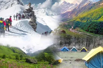
If you have ever dreamed of standing on a Himalayan summit with an unbroken panorama of snow-draped peaks stretching endlessly before you, the Pangarchulla trek is the adventure that was made for you. Nestled in the heart of the Garhwal Himalayas in Uttarakhand, this trek offers a rare combination of dense oak and rhododendron forests, sweeping alpine meadows, and a genuine high-altitude summit climb — all packed into a single, unforgettable journey. Whether you are a seasoned trekker looking for your next challenge or an enthusiastic adventurer stepping into serious Himalayan terrain for the first time, this guide covers everything you need to know before you lace up your boots.
Most treks in the Indian Himalayas take you through breathtaking landscapes and reward you with stunning views from a high-altitude pass or meadow. The Pangarchulla trek goes one step further — it culminates in an actual summit climb. You do not merely walk to a viewpoint; you stand on top of a peak. That distinction makes this trail one of the most sought-after high-altitude adventures in northern India.
The route weaves through a landscape that changes dramatically with every thousand meters of altitude gain. You begin in lush forests thick with birdsong, pass through meadows carpeted with wildflowers (or blanketed in snow, depending on the season), and eventually emerge onto a steep, icy slope that leads to the summit. The sense of achievement when you finally arrive at the top is something no photograph can fully capture.
Pangarchulla peak rises majestically above the treeline in the Chamoli district of Uttarakhand, forming a dramatic pyramid of rock and ice that is visible from several surrounding valleys. The peak sits at the edge of the famous Kuari Pass trail, sharing its neighborhood with legendary Himalayan giants. On a clear summit day, you can see Nanda Devi, Dronagiri, Hathi Parbat, Ghori Parbat, and the Trishul massif — a skyline that leaves even experienced mountaineers speechless.
The summit approach involves a steep snow and scree slope that requires the use of crampons and ice axes. This element of technical climbing is precisely what separates Pangarchulla from conventional Himalayan treks and elevates it into the category of a mountaineering expedition suited for the adventurous.
When you trek the Himalayas Pangarchulla, you are essentially following a route that traces some of the oldest shepherd paths in the Garhwal region. Uttarakhand is home to some of the most celebrated trekking places in Uttarakhand, and Pangarchulla stands among the finest — a trail that rewards every step with raw Himalayan grandeur. The standard itinerary begins from Joshimath, a bustling town in Chamoli district that serves as the gateway to several Himalayan adventures. From Joshimath, a short drive takes you to Dhak village, the actual trailhead from which you begin ascending into the mountains.
The trail passes through Gulling, a small shepherd settlement surrounded by towering oak and rhododendron trees, and then continues upward to Tugasi and eventually to the high-altitude base camp at Khullara. From Khullara, your summit push begins — typically before dawn, so that you reach the top in the morning hours when the weather is most stable and the views are clearest.
The descent retraces part of the route, offering you fresh perspectives on the landscape you climbed through on the way up.
A well-planned Pangarchulla peak trek typically unfolds over seven to eight days, allowing for gradual acclimatization and a comfortable pace.
Day 1 — Haridwar or Rishikesh to Joshimath Your journey begins with a long but scenic drive from Haridwar or Rishikesh through the Alaknanda valley to Joshimath. The road follows the river through narrow gorges and small hillside towns. Overnight stay in Joshimath.
Day 2 — Joshimath to Dhak to Gulling After breakfast, drive a short distance to Dhak village and begin the trek. The trail ascends steadily through mixed forests. Camp at Gulling, a beautiful clearing surrounded by oaks.
Day 3 — Gulling to Tugasi The trail continues through forest cover, gradually thinning as you gain altitude. Tugasi offers sweeping views of the surrounding ridges. Overnight camp.
Day 4 — Tugasi to Khullara As you emerge above the treeline, the views open dramatically. Khullara is a high meadow that serves as the base camp for the summit attempt. Acclimatize, hydrate, and prepare your gear.
Day 5 — Summit Day: Khullara to Pangarchulla Peak and Back This is the defining day of the expedition. Begin your ascent before dawn. The initial section crosses steep snow slopes, followed by a technical ridge leading to the summit. Descend back to Khullara for the night.
Day 6 — Khullara to Dhak and Drive to Joshimath Descend through the trail you know well. A vehicle awaits at Dhak. Drive back to Joshimath.
Day 7 — Joshimath to Haridwar or Rishikesh Return journey through the valley, carrying memories (and sore legs) from the mountains.
One of the most critical factors to understand before undertaking this expedition is Pangarchulla height. The summit stands at approximately 15,069 feet (4,593 meters) above sea level. This elevation places the peak well into the zone where altitude-related conditions such as Acute Mountain Sickness (AMS) can become a genuine concern for trekkers who are not properly acclimatized.
At this height, the air contains significantly less oxygen than at sea level, and the body must work considerably harder to perform even routine activities. Breathing becomes more labored, sleep quality often decreases, and physical effort feels disproportionately taxing. This is why the itinerary is designed with gradual altitude gain built in — giving your body the time it needs to adjust before you make the final push to the top.
Trekkers who come from coastal cities or low-altitude towns should ideally spend a day or two at Joshimath (altitude approximately 6,150 feet) before beginning the ascent. Hydration is important, and trekkers are advised to avoid alcohol and strenuous physical activity during the acclimatization phase.
Understanding Pangarchulla peak temperature is essential for packing the right gear and choosing the right time to attempt the summit. Temperatures on this trek vary enormously depending on the season, the altitude, and the time of day.
During the popular trekking months of April and May, daytime temperatures at the base camp (Khullara) can hover around 5°C to 10°C, while nights can plunge to -5°C or below. On summit day, particularly in the early morning hours, the temperature can drop further — often reaching -10°C or colder when wind chill is factored in.
In October and November, the other viable trekking window, temperatures are even sharper. Daytime on the trail might feel deceptively mild in the sun, but once the sun goes down or clouds roll in, cold sets in swiftly and aggressively. Summit day temperatures in November can dip to -15°C with wind chill, making proper layering absolutely non-negotiable.
Your gear list must include a down jacket rated for sub-zero temperatures, a quality sleeping bag rated to at least -10°C, thermal base layers, waterproof outer shells, insulated gloves, and a warm hat that covers your ears. Crampons and an ice axe are provided by most reputable trekking operators and are mandatory for the summit section.
For those planning their fitness training in advance, knowing the Pangarchulla trek distance helps structure an appropriate preparation program. The total distance covered across the entire trek — from Dhak village to the summit and back to Dhak — is approximately 55 to 60 kilometers, depending on the exact route and any detours.
On summit day alone, you will cover roughly 12 to 14 kilometers round trip from Khullara, with the majority of that distance involving significant elevation gain and loss. The ascent on summit day covers approximately 1,500 meters of vertical gain — a demanding challenge that requires strong legs, good cardiovascular fitness, and mental resilience.
To prepare adequately, trekkers should build an aerobic base through regular running, cycling, or hiking in the weeks leading up to the expedition. Stair climbing with a loaded backpack is one of the most effective training exercises for preparing your legs and lungs for this kind of sustained ascent.
A clear understanding of the Pangarchulla trek map helps you visualize the journey and prepare mentally for what lies ahead. The trek originates in Joshimath, located in Chamoli district, and the trailhead begins at Dhak village, which is roughly 14 kilometers from Joshimath by road.
From Dhak, the trail runs northeast through Gulling (approximately 7 km from Dhak), then continues to Tugasi (another 5 km), and climbs to Khullara (roughly 4 km further), which sits at an altitude of around 11,800 feet. The summit push from Khullara to Pangarchulla Peak covers approximately 6 to 7 kilometers one way, ascending nearly 3,300 feet of vertical gain through snow fields, scree, and a technical ridge.
The route shares terrain with the famous Kuari Pass trail for a portion of the journey, which means the landscape is well-documented and the paths are known to experienced guides. Most reputable trekking agencies provide detailed physical maps and GPS tracking devices for summit day. It is strongly advisable to hire a local guide who knows the terrain intimately, as visibility can deteriorate rapidly in the mountains and route-finding on snow requires experience.
The Pangarchulla weather dictates everything — your safety, your comfort, the quality of your views, and ultimately the success of your summit attempt. There are two primary trekking windows for this expedition, each with distinct characteristics.
April to June (Spring Window): This is the most popular time to attempt Pangarchulla. The weather is relatively stable, the days are long, and the rhododendrons paint the forests in vivid shades of red and pink. Snow is still present on the upper sections of the trail, which is ideal for the summit push. However, afternoon clouds can build quickly, and there is always the possibility of sudden snowfall at higher altitudes. Mornings are generally clear, which is one of the reasons summit attempts always begin before dawn.
October to November (Autumn Window): Post-monsoon skies are exceptionally clear, offering some of the sharpest mountain views of the year. The air is crisp and dry, and the autumn light bathes the landscape in a golden warmth. However, temperatures are significantly lower than in spring, and snowfall can arrive unpredictably. This window is better suited for trekkers who are already comfortable in cold conditions and have appropriate gear.
Months to Avoid: The monsoon season (July to September) renders this trek extremely dangerous. Heavy rainfall causes trail erosion, landslides, and treacherous river crossings. The summit section becomes hazardous with wet, unstable snow and ice. December through March sees the entire trail buried under deep snow, making it inaccessible to all but highly experienced mountaineers with specialized equipment.
The Pangarchulla Trek falls within a protected forest and national park zone, which means trekkers require specific permits. Your trekking operator will typically arrange the Inner Line Permit and the forest entry permit on your behalf, but it is important to confirm this before departure.
Joshimath is the last major town where you can withdraw cash, as ATMs become unreliable beyond this point. Mobile network coverage is available in Joshimath and Dhak but becomes patchy and eventually non-existent on the trail. Inform your family of this in advance and agree on communication checkpoints before you set off.
For trekkers who wish to fully explore Uttarakhand before or after the expedition, pairing this trek with a trusted uttarakhand travel agents from TourTravelWorld which gives you a seamlessly organized experience — from airport transfers and accommodation to permits, guides, and equipment.
Several lessons emerge repeatedly from trekkers who have completed this expedition and these insights can make your experience significantly smoother.
Start training at least eight weeks in advance: The summit day is genuinely demanding, and trekkers who arrive underprepared often struggle and may need to turn back before reaching the top.
Invest in quality footwear: Your boots must be waterproof, ankle-supporting, and compatible with crampon attachment. Do not attempt this trek in trail running shoes or low-cut hiking shoes.
Eat even when you are not hungry: At high altitude, appetite often diminishes, but your body needs consistent caloric intake to maintain energy and warmth. Force yourself to eat at every meal, even if just a small amount.
Listen to your body above everything else: No summit is worth a medical emergency. If you develop a persistent headache, nausea, confusion, or difficulty breathing, descend immediately and inform your guide. AMS can escalate rapidly.
Pack your crampons and ice axe correctly: These tools are essential for the summit section. If your operator provides them, learn how to use them properly before summit day — ask your guide for a demonstration at Khullara.
The Pangarchulla expedition need not stand alone. Uttarakhand is a state of extraordinary diversity — from the hot spring temples of Gaurikund to the wildlife-rich grasslands of Jim Corbett, from the serene ghats of Rishikesh to the high passes of the Niti Valley. For travelers who want a comprehensive understanding of this magnificent state before diving into their Himalayan adventure, consulting a detailed Uttarakhand travel guide before you leave home is invaluable for building a well-rounded itinerary.
The Pangarchulla trek is not merely a physical journey — it is a transformation. With every step you take through the rhododendron forests, across the alpine meadows, and up the final snow slope to the summit, you discover something about your own capacity for endurance, courage, and wonder. The Himalayas have a way of putting everything in perspective — the vastness of the sky, the silence of the high mountains, the humbling scale of the peaks around you — and Pangarchulla delivers all of this with exceptional intensity.
If you are ready to make this dream a reality and want a carefully organized, safe, and deeply enriching Himalayan experience, TourTravelWorld offers a thoughtfully curated Garhwal tour package designed to cover every aspect of your journey — from the moment you land in Dehradun to the moment you stand triumphant on the Pangarchulla summit and beyond. Rooted in deep local knowledge of the Garhwal Himalayas, their experienced guides and meticulous attention to detail ensure that every day in these magnificent mountains is nothing short of extraordinary. The peak is there. The trail is waiting. All you have to do is take the first step.
Ans: The best time is April to June for spring blooms and snow on the summit, and October to November for crystal-clear post-monsoon skies. Avoid the monsoon season (July–September) due to landslide risk.
Ans: Pangarchulla Peak stands at 15,069 feet (4,593 meters) above sea level, making it a genuine high-altitude summit climb rather than a standard Himalayan trek.
Ans: It is rated moderate to difficult. The trail involves steep snow slopes, use of crampons and ice axes on summit day, and significant altitude gain — making prior trekking experience highly recommended.
Ans: The complete trek typically takes 7 to 8 days, including travel from Joshimath, gradual acclimatization camps, the summit push, and the descent back to the trailhead.
Ans: The total trekking distance is approximately 55 to 60 kilometers from Dhak village to the summit and back, with summit day alone covering around 12 to 14 kilometers round trip.
Ans: It is not recommended for absolute beginners. Trekkers should have prior high-altitude experience, good physical fitness, and complete at least 6 to 8 weeks of cardiovascular training before attempting this summit.
Ans: Trekkers need an Inner Line Permit and a forest entry permit, both of which fall within the protected zone of the Garhwal Himalayas. Most reputable trekking operators arrange these permits on your behalf.