
- Home
- Travel Packages
- Top Destination
-
Travel Attraction
By Category
Top Attraction

- Travel Agents
- Car Rentals
- Hotels
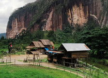
Harau Valley, also known as Lembah Harau, is one of the most breathtaking natural attractions in West Sumatra, Indonesia. Located near the town of Payakumbuh in the Limapuluh Kota Regency, this valley is often referred to as the “Yosemite of Indonesia” because of its dramatic granite cliffs and lush green surroundings. The valley is famous for its peaceful atmosphere, beautiful rice fields, towering rock walls, and multiple waterfalls. It is a paradise for nature lovers, hikers, photographers, and rock climbers seeking scenic views and local culture. How to Reach Harau Valley, Sumatra Harau Valley is located around 50 kilometers from **Bukittinggi**, a popular tourist town in West Sumatra, and about 120 kilometers from **Padang**, the capital city of West Sumatra Province. The nearest airport is **Minangkabau International Airport (PDG)** in Padang. From Padang, visitors can take a car, minibus, or public bus to **Payakumbuh**, which takes about 3 to 4 hours. From Payakumbuh, Harau Valley is just a 10 to 15-minute drive. You can hire a local taxi, rent a motorbike, or use a ride-hailing app if available. Weather at Harau Valley, Sumatra Harau Valley has a tropical climate, with warm temperatures and high humidity throughout the year. The temperature typically ranges from **22°C to 30°C (72°F to 86°F)**. The **dry season** runs from **May to September**, which is the best time to visit due to clearer skies and more comfortable trekking conditions. The **wet season**, from **October to April**, brings regular afternoon rains, but the valley remains green and the waterfalls more dramatic during this time. Visitors should be prepared for sudden weather changes in the highlands. Timings Harau Valley is accessible year-round and does not have fixed opening hours since it is a natural area. Most activities such as hiking, sightseeing, and visiting waterfalls are done during daylight hours, usually between **7:00 AM and 6:00 PM**. Some guesthouses in the valley offer early morning hikes and cultural tours, which can be arranged directly with the hosts. Why Famous for Harau Valley, Sumatra? Harau Valley is famous for its stunning **natural beauty**, especially its tall cliffs that rise up to 100 to 300 meters above the valley floor. The valley is surrounded by dramatic granite walls, which make it a favorite spot for **rock climbers**. Additionally, the lush paddy fields, quiet villages, and cascading waterfalls create a peaceful and scenic environment. The valley is also known for its **traditional Minangkabau culture**, which is reflected in the local architecture, cuisine, and way of life. It is a perfect mix of adventure and relaxation in a less-touristy setting. Entry and Visit Details about Harau Valley, Sumatra There is a small **entry fee** for visiting Harau Valley, which is usually around **IDR 5,000 to 10,000** per person. This fee is collected at a small post near the entrance to the valley. Some waterfalls or viewpoints inside the valley may charge additional minor fees. Most visitors stay in local **guesthouses or homestays** located within or near the valley. These accommodations are usually simple but comfortable and often include meals and tour arrangements. Rock climbing activities may require prior booking with local climbing guides. History and Architecture Harau Valley is not only a place of natural beauty but also a site of **cultural and historical significance**. The valley has long been inhabited by the **Minangkabau people**, known for their matrilineal society and distinctive architectural style. Traditional **Minangkabau houses**, called “Rumah Gadang,” feature pointed, curved roofs resembling buffalo horns. These houses can be seen in villages around Harau Valley. Some local legends and folklore are associated with the valley’s towering cliffs and natural features, adding to its mystique. Though not a man-made architectural wonder, the valley is deeply connected to the heritage of West Sumatra. Things to Do at Harau Valley, Sumatra Harau Valley offers a range of outdoor and cultural activities for travelers of all interests: Waterfall Visits: Explore famous waterfalls like Sarasah Bunta, Sarasah Lembah Harau, and Akar Berayun. These are great for photos, swimming, and relaxation. Rock Climbing: Harau is one of Indonesia’s top destinations for sport climbing, with dozens of bolted routes for climbers of all levels. Hiking: Take scenic hikes through rice fields and jungle trails. Some hikes lead to panoramic viewpoints over the valley. Village Tours: Visit local villages and learn about Minangkabau traditions, agriculture, and cuisine. Cycling: Rent a bicycle and enjoy a peaceful ride through the valley’s flat terrain surrounded by dramatic cliffs. Camping: Spend the night under the stars at designated camping spots or near waterfalls. Facts about Harau Valley, Sumatra The valley is part of the **Harau Nature Reserve**, covering about 270 hectares. Harau is often compared to **Yosemite National Park** because of its towering granite cliffs. There are over **300 bolted climbing routes** in Harau Valley, making it a favorite for international climbers. The area is home to a variety of **wildlife**, including gibbons, birds, butterflies, and monkeys. Rice cultivation and small-scale farming are the main livelihoods of the local population. Tips about Harau Valley, Sumatra Bring **comfortable walking shoes** or sandals suitable for uneven terrain and river crossings. Pack **insect repellent** and **sun protection**, especially if you plan on hiking or biking. Visit during **weekdays** to avoid crowds, especially during Indonesian holidays. Stay overnight in a local guesthouse to enjoy the peaceful night and early morning views. Respect the local culture and dress modestly, especially in village areas. Carry enough **cash**, as ATMs may not be available in the valley itself.
Explore More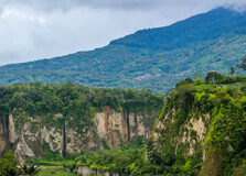
Ngarai Sianok, also known as the Sianok Canyon or Sianok Gorge, is a breathtaking natural wonder located in Bukittinggi, West Sumatra, Indonesia. This deep and lush canyon stretches for approximately 15 kilometers, reaching a depth of about 100 meters and a width of around 200 meters. The gorge lies at the foot of Mount Singgalang and Mount Marapi and offers visitors a magnificent view of steep cliffs, tropical vegetation, and a gently flowing river at its base. It is one of the most popular attractions in Bukittinggi, drawing nature lovers, photographers, and hikers from around the world. How to Reach Ngarai Sianok, Bukittinggi Ngarai Sianok is situated close to the center of Bukittinggi, making it easily accessible from anywhere in the city. The nearest major airport is Minangkabau International Airport (PDG) in Padang, about 95 kilometers away. From Padang, travelers can reach Bukittinggi by car, taxi, or bus in around 2.5 to 3 hours. Once in Bukittinggi, the canyon can be accessed by foot, bicycle, or a short car ride. It is located near Panorama Park, which is often the main entry point for visitors heading to the gorge. Weather in Bukittinggi Thanks to its elevation of nearly 930 meters above sea level, Bukittinggi enjoys a cool and pleasant climate year-round. Average daytime temperatures range from 18°C to 26°C (64°F to 79°F), making it ideal for outdoor exploration. The area experiences two primary seasons: the dry season (May to October) and the rainy season (November to April). The best time to visit Ngarai Sianok is during the dry season when the trails are less slippery and the views are clearer. Early morning or late afternoon visits offer the most comfortable temperatures and beautiful lighting for photography. Timing of Ngarai Sianok Ngarai Sianok is open to the public and accessible at all times, although it is best explored during daylight hours for safety reasons. Most visitors enter through Panorama Park, which is open from 8:00 AM to 6:00 PM daily. If you plan to explore deeper parts of the canyon or go trekking, it is recommended to start early in the day and finish before sunset. There is minimal artificial lighting in the gorge, and navigating after dark can be dangerous. Why is Ngarai Sianok Famous? Ngarai Sianok is famous for its stunning natural beauty and dramatic geological formations. It offers a unique combination of steep cliffs, verdant valleys, and peaceful riverside trails. The canyon is often called the “Grand Canyon of Indonesia,” although it has its own distinct tropical charm. Its scenic landscape makes it a favorite among photographers, hikers, and artists. Additionally, the canyon holds historical significance as it was once a hiding place during the Japanese occupation and Indonesian independence movement. Entry and Visit Details Visitors typically enter Ngarai Sianok through the Bukittinggi Panorama Park, where an entrance fee of around IDR 10,000 to 20,000 per person is charged (about $1 to $2 USD). This fee includes access to panoramic viewpoints, the entrance to Japanese caves (Lobang Jepang), and walking trails that lead into the canyon. There are also guides available for hire if you want a more in-depth tour or plan to go trekking along the Sianok River. Basic facilities such as restrooms, souvenir shops, and food vendors are available at the park entrance. History and Geology Ngarai Sianok was formed as a result of the tectonic activity of the Great Sumatran Fault (Semangko Fault), which caused the land to crack and shift, forming the deep canyon. The region’s volcanic and seismic activity continues to shape the landscape to this day. Historically, the gorge also played a role during the colonial and Japanese occupation periods. Near the canyon is the famous Lobang Jepang (Japanese Tunnel), a network of underground bunkers and tunnels built during World War II. This combination of natural and historical features adds a layer of depth to the visitor experience. Things to Do at Ngarai Sianok There are many activities to enjoy at Ngarai Sianok. For those who love nature, hiking and bird-watching along the canyon trails are highly recommended. The area is home to various species of flora and fauna, including monkeys, birds, and butterflies. Visitors can also explore the Japanese caves, which offer a glimpse into the wartime history of the region. Photography is another popular activity, especially from the viewing platforms in Panorama Park. For a more relaxed experience, visitors can take a picnic and enjoy the views from the many shaded spots along the trail. Guided river walks and local storytelling tours are also available. Facts and Tips about Ngarai Sianok, Bukittinggi Interesting Facts: - The canyon was formed by seismic activity along the Great Sumatran Fault. - Ngarai Sianok stretches over 15 kilometers and is over 100 meters deep. - The gorge has been a key location during historical conflicts, including the Japanese occupation. - The river running through the canyon is called Batang Sianok. - The nearby Japanese tunnels were dug by forced labor during World War II. Travel Tips: - Wear comfortable walking shoes, as the terrain can be uneven and slippery. - Bring water and snacks, especially if you plan to hike for several hours. - Hire a local guide if you want to learn more about the history and nature. - Bring a camera or smartphone — the views are incredible and worth capturing. - Avoid visiting during heavy rains as the paths can become muddy and unsafe. - Try to visit early in the morning to enjoy the peaceful surroundings with fewer crowds.
Explore More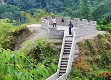
Janjang Koto Gadang is a unique and historical staircase pathway that connects the city of Bukittinggi with the village of Koto Gadang in West Sumatra, Indonesia. Often compared to the Great Wall of China on a smaller scale, this scenic stairway winds through lush green landscapes, offering panoramic views of Ngarai Sianok (Sianok Canyon) and the surrounding valleys. The path consists of hundreds of steps and is popular among hikers, nature lovers, and those seeking a peaceful walk amidst nature and history. It's one of the hidden gems of Bukittinggi and offers a different experience from typical tourist spots. How to Reach Janjang Koto Gadang, Bukittinggi Janjang Koto Gadang is located about 3–4 kilometers from the center of Bukittinggi. If you are already in Bukittinggi, you can reach the stairway entrance by local transportation such as “angkot” (public minivans), taxis, or motorcycle taxis (ojek). You can also walk from attractions like Taman Panorama or Lobang Jepang to the start of the trail. If you're traveling from outside Bukittinggi, the nearest airport is Minangkabau International Airport (PDG) in Padang, about 95 km away. From the airport, you can take a taxi, rent a car, or use an intercity bus to reach Bukittinggi. The journey takes around 2.5 to 3 hours. Weather in Bukittinggi The climate in Bukittinggi is cool and pleasant throughout the year due to its highland location at around 930 meters above sea level. Average temperatures range between 17°C to 26°C (63°F to 79°F). The dry season runs from May to October, while the rainy season is from November to April. The best time to walk Janjang Koto Gadang is during the dry season when the steps are less slippery and the skies are clear, offering the best views of the canyon and surrounding hills. Mornings and late afternoons are ideal due to cooler temperatures and softer sunlight. Timing of Janjang Koto Gadang Janjang Koto Gadang is generally open to visitors all day, though it's best visited during daylight hours from 6:00 AM to 5:30 PM. Since the area is an open-air trail with no artificial lighting, it is not suitable to visit after dark. Early morning is the most recommended time to enjoy a walk here, as the air is fresh and the path is quieter. Avoid visiting during heavy rain, as the stairs can become slippery. No formal ticket office exists at the entrance, but sometimes small local fees may be charged by community groups maintaining the area. Why is Janjang Koto Gadang Famous? Janjang Koto Gadang is famous for its scenic beauty, cultural heritage, and its similarity to the Great Wall of China. The stairway stretches across steep hillsides and offers dramatic views of the Ngarai Sianok gorge and surrounding greenery. It also connects two culturally rich locations — Bukittinggi and Koto Gadang — both known for their historic importance and traditional Minangkabau customs. The walk itself is peaceful and meditative, attracting photographers, hikers, and travelers who want to explore beyond typical urban sights. The path gives a taste of rural West Sumatra while still being very close to the city. Entry and Visit Details Entry to Janjang Koto Gadang is generally free, though small donations or community maintenance fees (around IDR 5,000 or less than $1 USD) might be requested at some entrance points. The stairway can be accessed either from the Bukittinggi side, near Panorama Park or Lobang Jepang, or from the Koto Gadang village side. It’s advisable to wear comfortable walking shoes and bring drinking water. There are a few rest stops along the way, but there are no toilets or food stalls directly on the path, so plan accordingly. It’s also recommended to bring a camera for the spectacular views. History and Architecture The Janjang Koto Gadang stairway was originally built during the Dutch colonial period as a footpath linking Bukittinggi and Koto Gadang. The trail was later renovated to make it more accessible and safer for tourists and locals. Its architecture is simple yet functional, consisting mainly of stone steps, railings, and scenic viewpoints. Although it is not grand in scale, its winding path and strategic positioning along the canyon walls have earned it the nickname “Mini Great Wall of Bukittinggi.” The trail reflects the practical and community-based engineering of earlier generations, showcasing how people used natural landscapes for connectivity and mobility. Things to Do at Janjang Koto Gadang Walking the Janjang Koto Gadang trail is the main activity, and it provides a unique opportunity to enjoy nature while also getting some exercise. Along the way, you can stop to take in the incredible views of the canyon and forested hills. Birdwatching and photography are popular here, especially around sunrise or sunset when the lighting is dramatic. At the Koto Gadang end of the trail, you can explore the village, which is known for silver handicrafts, traditional Minangkabau houses, and local snacks. Some visitors also use this trail as part of a longer hike connecting multiple attractions in the Bukittinggi area. Facts and Tips about Janjang Koto Gadang, Bukittinggi Interesting Facts: - The name "Janjang" means staircase in the Minangkabau language. - The trail has over 300 steps and stretches approximately 1 kilometer. - It connects Bukittinggi city with the culturally important village of Koto Gadang. - The trail offers a bird’s-eye view of the Ngarai Sianok, a deep and scenic canyon. - Janjang Koto Gadang has been featured in many travel blogs and is a popular Instagram spot. Travel Tips: - Wear sturdy walking shoes with good grip, especially if visiting during the rainy season. - Bring a bottle of water and wear sunscreen or a hat for sun protection. - Visit early in the day to enjoy cooler weather and fewer visitors. - Avoid visiting when it's raining heavily, as the steps can become slippery. - Bring a camera or smartphone to capture panoramic shots of the canyon and hills. - Respect the environment — do not litter and stay on the designated paths. - If visiting with elderly or very young children, consider only walking part of the trail. l>
Explore More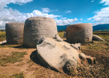
Bada Valley is a remarkable archaeological and natural site located in the Lore Lindu National Park in Central Sulawesi, Indonesia. Renowned for its mysterious ancient megalithic statues scattered throughout the valley, Bada Valley offers visitors a unique glimpse into the prehistoric culture of Sulawesi. The valley is surrounded by dense tropical forests and mountainous terrain, which adds to its mystical aura. Apart from its archaeological significance, Bada Valley is also known for its beautiful landscapes, biodiversity, and cultural heritage of the local indigenous communities. It is an extraordinary destination for history enthusiasts, archaeologists, nature lovers, and travelers seeking off-the-beaten-path experiences. How to Reach Bada Valley, Sulawesi To reach Bada Valley, travelers generally start from the city of Palu, the capital of Central Sulawesi. From Palu, visitors can hire a private vehicle or take local buses towards the Lore Lindu National Park area. The journey to Bada Valley takes approximately 5 to 7 hours depending on road conditions, as the roads are mountainous and sometimes rough. The nearest town to the valley is Kulawi, where local guides can be hired to navigate the site and the surrounding areas safely. It is advisable to arrange transport and guides in advance due to the remote location and limited public transport options. Visitors should be prepared for a rugged journey but are rewarded with stunning scenery along the way. Weather in Bada Valley Bada Valley experiences a tropical rainforest climate with warm temperatures ranging between 20°C and 30°C (68°F to 86°F). The region receives significant rainfall, especially during the wet season from November to April. The dry season, from May to October, is the best time to visit because the weather is more stable and the trails around the valley are easier to explore. Due to its elevation, evenings and mornings can be cool, so visitors are advised to bring appropriate clothing. Rainfall can make trails slippery and challenging during the wet months, so proper footwear and rain gear are essential for those visiting during this time. Timing to Visit Bada Valley The ideal time to visit Bada Valley is during the dry season, from May to October, when the weather is more predictable and the conditions are best for hiking and exploring the megalithic sites. During this period, the valley is accessible with less risk of landslides or flooding. The months of July and August tend to be the peak tourist season due to holidays, so booking accommodations and guides ahead of time is recommended. Visitors should avoid the wet season if possible, as heavy rains can hinder access and reduce the overall experience. Why is Bada Valley Famous? Bada Valley is famous primarily for its megalithic stone statues, some dating back over a thousand years, which are scattered across the valley. These statues are carved from volcanic rock and depict human figures, animals, and mysterious symbolic shapes. The origins and purpose of these megaliths remain subjects of research and speculation, adding to the valley’s allure. Besides its archaeological wonders, Bada Valley is also notable for its natural beauty, rich biodiversity, and the traditional lifestyles of the local Pamona and Lore ethnic groups. The valley offers an authentic cultural and historical experience combined with breathtaking natural scenery. Entry and Visit Details about Bada Valley There is a nominal entrance fee to access Bada Valley, which is usually collected by local authorities or park management to support conservation efforts. Visitors are encouraged to hire local guides for safety and to gain deeper insights into the archaeological sites and cultural context. Guides can be arranged in Kulawi or through travel agencies in Palu. Facilities in the valley are basic, so travelers should prepare accordingly, bringing enough water, food, and supplies. Overnight accommodation options are limited, with some basic homestays and guesthouses available in nearby villages. Camping is possible with proper permits and equipment. History and Architecture of Bada Valley The megalithic statues of Bada Valley are believed to have been created by ancient inhabitants of Sulawesi as part of their religious or cultural practices. The statues range in size from a few centimeters to several meters tall, some depicting human forms with detailed facial features and postures. These megaliths were carved from volcanic rock found locally and placed in various parts of the valley, possibly as markers of sacred sites, ancestral spirits, or territorial boundaries. Although the exact age of the statues is uncertain, some are estimated to be over 1,000 years old, making them some of the oldest megalithic remains in Indonesia. The architecture of the statues reflects a sophisticated craftsmanship and provides valuable clues about the prehistoric societies of Sulawesi. Things to Do in Bada Valley Visitors to Bada Valley can engage in several activities that highlight both the cultural and natural features of the region. Exploring the megalithic statues with a knowledgeable guide is a must, as many of the carvings are hidden among dense vegetation and require explanation to understand their significance. Hiking trails through the surrounding forests and hills offer stunning views and opportunities to spot local wildlife, including endemic bird species and unique plants. Cultural experiences include visiting nearby villages to learn about the traditions, crafts, and daily life of the indigenous communities. Photography enthusiasts will find the valley’s combination of ancient statues and natural beauty an inspiring subject. Additionally, camping and eco-tourism are available for those wanting a more immersive experience. Facts and Tips about Bada Valley Facts: - Bada Valley is part of Lore Lindu National Park, a UNESCO Biosphere Reserve. - The valley contains over 400 megalithic statues. - Many statues depict human figures with detailed facial features. - The valley is home to various endemic species of flora and fauna. - The local Pamona and Lore people have preserved many ancient customs and traditions. Tips: - Hire a local guide to navigate and gain deeper insights into the megaliths. - Visit during the dry season (May to October) for easier access and better weather. - Wear sturdy hiking shoes and bring insect repellent. - Carry sufficient water and snacks as facilities are limited. - Respect local customs and ask permission before photographing people. - Plan accommodations in advance due to limited options near the valley. - Be prepared for basic amenities and consider camping for a unique experience. - Support local communities by buying handmade crafts and using local services.
Explore More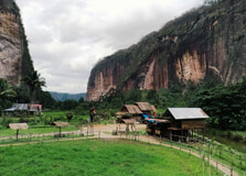
Harau Valley is one of the most beautiful and breathtaking natural wonders in West Sumatra, Indonesia, located about 50 kilometers from Padang. Known for its dramatic landscapes, towering cliffs, lush green rice fields, and cascading waterfalls, Harau Valley is a haven for nature lovers and adventure seekers alike. The valley is surrounded by steep limestone cliffs that rise up to 150 meters, with various waterfalls adding to its majestic beauty. This area is ideal for hiking, photography, and experiencing the beauty of Indonesia’s natural landscapes. How to Reach Harau Valley, Padang Getting to Harau Valley from Padang is relatively easy, and there are a few transportation options to choose from: By Car or Taxi: The most convenient way to reach Harau Valley is by renting a car or taking a taxi from Padang. The journey typically takes about 1.5 to 2 hours, depending on traffic and road conditions. By Motorbike: If you're an adventurous traveler, you can rent a motorbike and enjoy the scenic ride to the valley. It's a popular option among locals and tourists alike. By Public Transport: You can take a minibus (known as an angkot) from the center of Padang to the nearby town of Bukittinggi, and then continue by local transport to Harau Valley. However, this option can be less convenient and time-consuming. Weather and Best Time to Visit Harau Valley Harau Valley experiences a tropical climate, with warm temperatures and a mix of wet and dry seasons. The weather in the valley is generally mild, with temperatures ranging from 25°C to 30°C (77°F to 86°F) throughout the year. The rainy season lasts from October to April, and it’s best to visit during the dry season from May to September to enjoy the valley's beauty in full bloom. The best time to visit Harau Valley is during the dry months, especially between June and August when rainfall is minimal, and the waterfalls are at their most spectacular. However, the lush green rice fields and the cool, fresh air make it a beautiful place to visit year-round. Timing and Entry Details for Harau Valley Harau Valley is an open natural destination, and there are no specific opening or closing hours. Visitors can explore the valley at their leisure. However, it’s advisable to visit during daylight hours for safety and to fully enjoy the natural scenery. Most people visit the valley between 8:00 AM and 4:00 PM. There is generally no entry fee for visiting Harau Valley, though some of the attractions like waterfalls or certain viewpoints may have a small fee for maintenance or parking. Why Harau Valley is Famous? Harau Valley is famous for its dramatic scenery and pristine natural beauty. The valley is bordered by towering limestone cliffs and features stunning waterfalls, including the famous Sarasa Waterfall. It’s a perfect location for outdoor activities such as hiking, trekking, and photography. The lush landscapes, combined with the rural setting, provide a peaceful retreat from the hustle and bustle of city life. The valley is also known for its agricultural richness, with rice fields and tropical vegetation thriving here. The region is often called the "Tropical Wonderland" due to its biodiversity and vibrant landscapes. It's also home to several traditional villages that showcase the Minangkabau culture and lifestyle. History and Architecture of Harau Valley Harau Valley has long been inhabited by the Minangkabau people, who have shaped the landscape with their traditional rice paddies and villages. The valley’s unique geological formations date back millions of years and have become a crucial part of the area's natural heritage. The valley’s architecture consists mainly of traditional Minangkabau houses, known as "Rumah Gadang." These houses are easily recognizable by their large, sweeping roofs that resemble buffalo horns. The local communities have preserved these houses and maintain their customs, offering visitors a glimpse into the region’s cultural heritage. Things to Do at Harau Valley Hiking and Trekking: Harau Valley offers several trekking trails that lead you through its lush forests, past waterfalls, and up to viewpoints where you can admire panoramic views of the valley. Visit Waterfalls: The valley is home to several waterfalls, the most famous of which is Sarasa Waterfall. Visitors can take a refreshing dip in the natural pools or simply enjoy the beauty of the cascading water. Photography: The valley is a photographer’s paradise, with its stunning landscapes, dramatic cliffs, and waterfalls providing perfect photo opportunities. Explore Traditional Villages: The surrounding villages offer a unique cultural experience where you can see traditional Minangkabau houses, interact with locals, and learn about their way of life. Bird Watching: The area is rich in biodiversity, and birdwatchers will enjoy spotting various species of local and migratory birds in the forests and rice fields. Camping: For nature lovers, camping in the valley is an exciting option. There are several camping sites in the area where you can enjoy the fresh air and stunning views. Interesting Facts about Harau Valley Harau Valley is surrounded by towering cliffs, some of which rise as high as 150 meters (492 feet) above the valley floor. The valley is home to a rich variety of flora and fauna, making it a great destination for nature enthusiasts. It is a popular spot for local and international tourists who are drawn to its beauty, tranquility, and outdoor activities. The Sarasa Waterfall, which is one of the main attractions of the valley, has a height of approximately 75 meters (246 feet). The valley is part of the Bukittinggi region, which is known for its cool climate and scenic beauty. Tips for Visiting Harau Valley Wear Comfortable Footwear: The terrain in Harau Valley can be rough, especially when trekking or exploring the waterfalls, so make sure to wear comfortable shoes. Carry Water and Snacks: There aren’t many shops in the valley, so it’s a good idea to bring along water and snacks for the journey. Respect Local Culture: While visiting the surrounding villages, be respectful of local customs and traditions. Bring a Camera: Don’t forget your camera to capture the breathtaking views of the valley, waterfalls, and local life. Check Weather Forecast: Since the valley is subject to occasional rainfall, check the weather forecast before you visit to avoid being caught in a storm. Conclusion Harau Valley is undoubtedly one of the most beautiful and serene destinations in West Sumatra. Whether you're a nature lover, photographer, or adventure enthusiast, this hidden gem offers a wealth of experiences that are sure to leave you in awe. From hiking to stunning waterfalls to immersing yourself in local Minangkabau culture, Harau Valley is a place where you can enjoy the wonders of nature and history in perfect harmony.
Explore More