Snow clad mountains and glittering lakes; Himachal Pradesh is the best place to meditate and escape from the polluted cities. Switzerland of India, Himachal Pradesh with its beautiful temples and monasteries is heaven for adventure sports. Try out on adventures like paragliding, ice skating and fishing with Manali Packages. The truly blessed destination, Manali with its pine clad mountains and rich floral hues offers everlasting beauty. Visit Manali for its 450 year old temple and Tibetan Monastery for its artistic carving when on Manali Tours. A small village called Vashisht which is famous for its hot springs which has medicinal properties is also included in Manali Tours Packages. Rohtang Pass with its shiny glaciers and peaks gives you a feeling of heaven on earth. Visit to colorful markets selling handicrafts and artistic items on mall road Kullu Manali SHIMLA The British empire may have ceased to exit, but its echo lingers on in Shimla (2205m). As the Summer Capital of the British in India, Shimla was the country's focus for the better part of every year and now, is the state capital of Himachal Pradesh. Today, it has well developed facilities, easy accessibility and numerous attractions making it one of India's most popular hill resort. Situated in the lower ranges of the Himalayan mountains, it is surrounded by pine deodar, oak and rhododendron forests. Towards the north lie the snow-covered high-ranges, while the valleys breathe whispering streams and swaying fields. Within the town are host of splendid colonial edifices, quaint cottages and charming walks. Shimla offers a variety of shopping, sport and entertainment activities ACCESS The airport is at Jubbar-Hatti, 23 km away. Shimla is connected to Kalka by an enenchanting narrow gauge railway line where even a quaint rail car ply. By road, Chandigarh is 117 km, Manali is 280 km, Chail is 45 km and Delhi is at a distance of 370 km. From Delhi, Manali and Chandigarh, luxury coaches and taxis ply to Shimla. During tourist season HPTDC also operates regular deluxe buses from Delhi and Manali to Shimla. CLIMATE In winter, the temperature can drop below freezing point when heavy woolens are required. Summer temperature are mild and light woolens/cottons are recommended. PLACES OF INTEREST THE RIDGE: This large open space in the heart of town presents excellent views of the mountain ranges. Shimla's landmarks - the neo- gothic structure of Christ Church and the neo - Tudor library building - are worth seeing. LAKKAR BAZAR: Popular for its wood crafts and Souvenirs, this is just off the Ridge. JAKHOO HILL (2.5 km): At 2455m, this is the town's highest peak and a famous point for Shimla's famous views. The summit is crowned with a temple dedicated to Lord Hanuman. The hill is full of paths and narrow roads which are enjoyable walks. ST. MICHAEL'S CATHEDRAL: This dressed-stone church with fine stained glass has a cruciform design. It is located just off the Mall, below the District Courts. JOHNNIE'S WAX MUSEUM : The museum feature life-size wax statues of popular personalities from various fields, such as Hollywood, Bollywood, Politicians, Sports etc, like Madame Tussauds, London - the most famous wax museum in the world. The Museum is located HPTDC Lift, The Mall, Shimla. STATE MUSEUM (3km): This houses a representative collection of Himachal's rich heritage. Exhibits include archaeological artifacts, carvings, paintings and sculptures. Closed on Monday and holidays. INDIAN INSTITUTE OF ADVANCED STUDY (4 km): At 1983m, this magnificent English renaissance structure was the former Viceregal Lodge. Its lawns and woodland are added attractions. Entry by ticket ( nominal charge ). A portion of the interior is also open to the public, except on Sundays and holidays. THE GLEN (4 km ): At 1830m, It is a thickly wooded ravine through which a stream flows. It is a popular picnic spot. ANNANDALE (4.5 km): Surrounded by a thick deodar forest, this large glade has an ancient temple on the edge. PROSPECT HILL AND KAMNA DEVI ( 6 km): At 2125m and crowned by a temple dedicated to Kamna Devi, the Hill offers spectacular wide views of the city and its environs. SANKAT MOCHAN (7 km): This is a temple dedicated to Lord Hanuman. TARA DEVI (11 km): 2044m, A thickly wooded hill with a temple dedicated to Tara Devi. MASHOBRA (12 km): At 2149m, this beautiful suburb is surrounded by thick forests. From here, a track leads down to Sipur which is an exquisite glade shaded by ancient deodar trees. There are old temples a fair is held every April. KUFRI (16 km): At 2501m, this is famous for its wide views and ski slopes. An enjoyable walk leads up to the Mahasu Peak. At Kufri, Himachal Tourism runs Cafe Lalit. FAGU (22 km): At 2510m, Fagu has some enchanting views. Himachal Tourism run Hotel Peach Blossom offers spectacular views. CHAIL (45 km): This was a former Summer Capital of the Patiala State. The Palace has been converted to a Luxury Hotel by Himachal Tourism. TATTAPANI (51 km): At 656m, there are hot sulphur springs believed to have medicinal value. FAGU Fagu is a tiny village aside a saddle-like mountain along Hindustan Tibet Road. A rare range of views is visible from here, which include vivid dales and snow clad peaks. The picturesque countryside is dotted with clusters of villages, fruit gardens and nearby terraced fields. Fog characterizes the hillside landscape endowed with romantic ambience. Most of the area is covered with conifers of Himalayan cedar and spruce. Located at an altitude of 2,450 m, Fagu, perhaps have derived its name from the fog itself. ACCESS : The closest airport is at Jubbar-Hatti, 45 km away. The nearest narrow gauge railhead is at Shimla, 22 km away. By road Chandigarh is 139 km and Delhi is at a distance of 392 km. CLIMATE : In winter, the temperature can drop to below freezing point when heavy woolens are required and in summers light woolens / cottons are recommended. PLACES OF INTEREST KUFRI (4 km): (2510 m) Famous for its ski slopes also have enjoyable walks leading up to Mahasu Peak in proxomity. A Nature Park and Mini Zoo are other places worth visiting. Hill ponies and Yaks are available for a joy ride. HiPTDC here runs Cafe Lalit. SHIMLA (22 km): (2205 m) Once a summer seat of Britesher, Shimla is now the state capital of Himachal Pradesh. It has the rarest of the rare heritage buildings and monuments of the bygone area. Worth seeing places are - The legendary Mall Road, The Ridge, The Christ Church, Kali Bari Temple, Jakhu Hanuman Temple, Sankat Mochan, State Museum, Institute of Advanced Studies. CHAIL (27 km): (2226 m) provides many bounties of nature. Once the summer capital of Maharaja of Patiala, the Kingly Palace decorated with some historical objects as well, is now owned as a Heritage building by HPTDC. Also famous for the world's highest Cricket Ground, Wildlife Sactuary and Sidh Baba ka Mandir. NARKANDA (42 km): (2708 m) On the Hindustan Tibet road, Narkanda offers a spectacular view of higher snow ranges. An uphill trek (8 km) through deodar woods leads beholder to Hatu Peak famous for ancient Hatu Mata Temple (3475 m) which is now connected with a motorable road. During winter, under the aegis of HPTDC, skiing is also conducted here. Kotgarh and Thanedhar, Himachal's Apple heartland famous for delicious apples are located in vicinity. HPTDC runs Hotel Hatu at Narkanda. NALDEHRA Located at distance of 22 km from Shimla, Naldehra (2044 m) is a heaven for tourists. It boasts of the oldest 9 hole golf course in the country. The well groomed Golf Course is a lovely verdant, perhaps one of the finest and sporty in India. Crowned with a springing turf the Golf Course was suggested by Lord Curzon. He was so enchanted by the place that he gave his daughter Alexendra, "Naldehra" as her second name. It is the venue of many competitions. The Nag temple is also situated here and Naldehra derives its name from it. ACCESS : The closest airport is at Jubbar-Hatti, 45 km away. The nearest narrow gauge railhead is at Shimla, 23 km away. By road Chandigarh is 139 km, Manali is 282 km and Delhi is at a distance of 392 km. CLIMATE : In winter, the temperature can drop to below freezing point when heavy woolens are required and in summers light woolens / cottons are recommended. PLACES OF INTEREST Golf Course Naldehra is famous for world famous Golf Course. TATTAPANI At 656m, there are hot sulphur springs believed to have medicinal value. CHINDI Hillsides covered with thick forests, acres filled with apple orchards, small picturesque hamlets and remarkable views in all directions combine to make Chindi (1825 m) and the area around it, one of the most beautiful places in Himachal Pradesh. The area is still off the beaten track and yet, has good facilities in terms of roads, small markets and accomodation. Chindi is an excellent off-beat destination that holds the charms that Himachal is just famous for. ACCESS : The closest airport is at Shimla at Jubbar-Hatti, 110 km away. The nearest narrow gauge railhead is at Shimla, 87 km away. By road Mandi is 100 km, Rampur via Baina Khud is 92 km, Chandigarh is 204 km and Delhi is 457 km. The road from Shimla passes through Naldehra, Tattapani, Al Chindi and Churag. CLIMATE : In winter, the temperature can drop to below freezing point when heavy woolens are required and in summers, light woolens / cottons are recommended. PLACES OF INTEREST The wide Karsog Valley lies below Chindi and has good excursion spots. Apple orchards add thir attraction to the area and Chindi is surrounded by them. The area has several temples that display a high level of traditional craftmanship. Some of the important temples are - Mamleshwara Mahadev, Kamakshya Mata, Mahunag, Ardhnarishwara, Aledi Mahadev, Palinag at Nalagali, the sacred Bhima Rock, Churag temple, Nag Dhamooni at Sairi Bangla, temple at Chatri and the temple of Nag Dhamooni at Saranda. The hike to Shikari Devi (3359 m) is possible from Chindi. The views from Kunhoo Dhar (23 Km) are spectacular. BAROG On the Kalka - Shimla Highway, Barog (1680m) has grown from a mere stopover to a full-fledged destination. Surrounded by pine and oak forests, Barog has a commanding setting. Barog makes a conveniently accessible destination and a travel stopover to or from Shimla. ACCESS : The closest airport is at Jubbar-Hatti, 65 km away. The nearest narrow gauge railhead is at Barog itself. By road Chandigarh is 62 km and Shimla is 55. CLIMATE : In winter, the temperature can drop near to freezing point when heavy woolens are required and in summers light woolens / cottons are recommended. PLACES OF INTEREST RAILWAY STATION (3 km) : One of the most attractive station in the Scottish style on the Kalka - Shimla rail route. DAGSHAI (7 km) : A one time British cantonment. This is small town surrounded by pine trees and has an old church. SOLAN (8 km ): Located on the National Highway - 22 Solan derives its name from "Shoolini Devi" a local deity whose temple is situated in Solan Graon which is in existence since ancient times. Solan also remained capital of erstwhile Bhagat State for many years. A famous "Shoolini Fair" is commemorated every year in 2nd week of June at Thoda Ground. The town has various cultural and recreational centers besides temples and churches. There are beautiful parks such as Children Park, Mohan Park and Jawahar Park which have adequate arrangements for comfortable sitting and strolling. A mini zoo in the park adds to the fascination of the environment. Durga Club, Central State Library, Lower and Upper Bazaar and Mall road are worth visiting. Ancient Durga Temple, Sanatan Dharm Mandir, Hari and Narsingh Mandir are also quite famous. SOLAN BREWERY (11 km) : This is in existence since 1855 AD. Formerly Dyer Meakin Brewary, it is not only known in the country but also in foreign countries for its products. JATOLI (15 km) : 7 km from Solan this small but beautiful village on Solan - Rajgarh road famous for Vishal Shiva temple. DOLANJI BON MONASTERY (18 km) : On Solan - Rajgarh road there is a small village known as Ochhghat. 5km from here on Narag-Sarahan road, located at famous Bon Monastery known 'Yungdrung Bon Monastery' being run by Yungdrung Bon Monastic Centre. This was founded in 1969 by the Abbot Lungtog Tenpai Nyima. After 14 years of hard work, he managed to create a totally self sufficient monastery with 120 monks, developing it into a thriving, active centre of all branches of Tibetan traditional learning. On the eve of New Year and on other occasions three sacred Bon dances are performed here which are of great attraction. KAROL GOOFA (17 km) : On the Karol Tibba (2135m) and 8 km from Solan town is an ancient Sidh Goofa which is considered to be one of the longest Goofa in Himalayan region. It starts from Karol and ends somewhere at Pinjore. Besides Goddess Kali and Lord Hanuman temples, Thakur Mandir on top of the hill are some the great attractions for the pilgrims and visitors. The trek up to Karol is steep but quite enjoyable. This place is very popular amongst the trekkers and adventurous picnickers. HORTICULTURE AND FORESTRY UNIVERSITY (16 km) : In the surroundings on Rajgarh Road the University is an unique centre of higher studies and research in horticulture and forestry. The entire campus is worth seeing. GAURA : Located alongside the Solan - Rajgarh road, this place is famous for Mahasheer fishing in Giri river. RAJGARH (53 km): A picturesque area with numerous orchards and picnic spots like Habban and Nacchana. RENUKA JI The Renuka Lake (660 m) is regarded as the embodimezznt of Renukaji, the wife of sage Jamadagini and mother of Parshuram, one of the ten Avtars of Lord Vishnu. Shaped like a profile of a woman, the lake has the circumference of 2.5 km and is the largest in Himachal. This placid stretch of water is fed by underground springs and the surrounding hills are padded by lush forests that support a large variety of plant and animal life. Boating and trekking are the additional attractions of Renukaji, whose natural beauty has to be seen to be believed. This is perfect year around destination that beckons every traveler. ACCESS : Renukaji is connected by road. It is 315 km from Delhi. The nearest rail head is at Ambala (95 km) Dehradun (105km) and Chandigarh (95 km). The nearest airports are at Chandigarh and Dehradun. Taxis/buses are available for Renukaji at all places. CLIMATE : In winter, the climate is pleasant and light woolens are suggested. Summer temperature are high and cottons are recommended. PLACES OF INTEREST RENUKA LAKE : Legend has it that when the evil Sahasarjuna killed the sage Jamadagini and tried to abduct his wife Renuka. She flung herself into the water. The gods restored her to life and this lake is regarded to be her embodiment. There is a row of temples along its banks, and a track encircles the water. Boats are available on hire next to the hotel. NARKANDA Situated at an attitude of 2708 meters on the Hindustan Tibet road (NH - 22), Narkanda offers a spectacular view of snow ranges. This is an ideal retreat for the tourists who seek seclusion in mountains. It commands an unique view of the eternal snow line, the inviting apple orchards and dense forests. Narkanda is famous for Skiing & Winter sports. During these days the slopes come alive with skiers. The skiing at Narkanda was started in 1980 and since then HPTDC is conducting skiing courses every year. Narkanda is a gateway to apple country of Himachal Pradesh. . ACCESS : 65 km. from Shimla, it is connected by Bus/Taxi services. Nearest Railway Station (65 km) and Airport (88 km) are at Shimla. CLIMATE : In winter, the temperature can hover around freezing point when heavy woolens are required. During summer, the climate is pleasant and cottons / light woolens are suggested. Narkanda receives heavy snowfall in winters. PLACES OF INTEREST HATU PEAK (3300m) : 8 km from Narkanda, the road is surrounded by pine and spruce trees. On top of the hill, ancient Hatu Mata temple is located. The peak offers spectacular view of the entire Himalayan ranges, snow clad mountains and in depths are the dense forests, green fields and apple orchards. Hiking is recommended to reach the peak KACHERI (1810m) : This place is located 0.5 km from Oddi, and 7 km from Narkanda on NH - 22 and famous for ancient Mahamaya Temple. KOTGARH AND THANEDHAR (1830m) : 17 km link road bifurcating from Narkanda takes you to the Himachal's Horticultural heartland, Kotgarh and Thanedhar, renown for apple orchards. The famous Stokes Farm is located at Thanedhar. Stokes came to India on a trip and while on a summer visit to Shimla, fell in love with its environments, which included the charming hill folk and settled down in Kotgarh. He started the apple farm which soon became renown with its Red Delicious, Golden Delicious and Royal Delicious,apples. JALLORI PASS (3,550 m) : 90 km from Narkanda, passing through the Sutlej Valley and crossing over to Luhri, Ani, Khanag through one of the best scenery in the Kullu Valley takes you to Jallori Pass. A 30 minute level walk from the Pass takes you to Sarolsar Lake among deep forests. See nature at it's best. PARASHURAMA TAL AND RENUKA TEMPLE (100M) : At the base of the Renuka lake, this large pool is considered to embrace Lord Parshurama, who wished to spend all eternity at his mother's feet. Reportedly built overnight by an invading force of Gurkhas in early 19th Century, the original temple of Renukaji is here. Both mother and son are reunited every year at a celebratory fair held in November. JAMU PEAK (8 km) : Above the lake is the peak where Rishi Jamadagini is said to have meditated. A footpath leads to the peak. There is a small temple and it offers an excellent view of the lake and surrounding area. MINI ZOO (2 km) : You can boat across the lake or drive to this zoo, which has Asiatic lions, spotted deer, lion tailed macaques, 'Nilgai' Methuen, barking deer and Himalayan black bears. LION SAFARI (2 km) : Adjoining the zoo, an armored van enters the large enclosure allowing for a close glimpse of the lions within. JATAUN (5 km) : The dam of the Giri Hydel Project is here and angling for Mahaseer (river carp) may be done. RAMPUR Once the capital of the princely State of Bushahar, Rampur is presently one of the biggest commercial town of Himachal Pradesh. It is located on the left bank of river Sutlej. The town was once a major center on the old trade route to Kinnaur, Tibet, Ladakh and China. Even today the tradition is as vibrant as ever. Famous International Lavi Fair is held in November and Faag Mela in March every year. ACCESS : 134 kms from Shimla on NH - 22. Rampur is connected by regular Bus/Taxi services. The nearest Railhead (134 km) & Airport (157 km) is at Shimla. Rampur can be approached from Rohru via Sungri ( 80 km ) and from Kullu, Manali via Jalori pass ( 190 Km). CLIMATE : In winter, the temperature can drop below freezing point when heavy woolens are required. In summer the temperature rises upto 40 degrees. PLACES OF INTEREST RAMPUR TOWN (924m) : There are many places for sight-seeing. Its old Hindu and Buddhist shrines include the Ragunath Temple, the Ayodhya Temple, the Narsingh Temple and the Dumgir Budh Temple which has a large prayer wheel and holds important scriptures. In an interesting colonial and traditional styles, the Padam Palace is one of Rampur's major attractions. DUTT NAGAR (970m) : 12 km ancient village on the left bank of Sutlej which derived its name from the ancient temple of god Dattreya. NIRATH (950m) : 18 km, famous for ancient and unique Sun Temple built in nagara style is one of the two temples in India dedicated to Lord Suryanarayan. SARAHAN The Gods were generous when they have gave Sarahan (2165m) its settings. Located halfway up a high mountain side, the road to Sarahan winds past flowering Pine trees that give way to stately Oaks. Dozens of small streams rush past. The fields and orchards that surround the small villages with their slate roofed houses, compose pictures of pastoral perfection. Above Sarahan, a many deodar trees rides the slopes and higher still, encircling the Bashal peak, are trees of smooth birch and variety of wild flowers and rare medicinal herbs. This sparsely populated tract is steeped in ancient legends and here is the famous Bhimakali temple regarded as one of the Fifty One sacred Shaktipeethhs. The temple's unusual architecture and wealth of carvings have made it a resplendent example of what is loosely called the Indo-Tibetan style. Deep down the alley flows the river Sutlej and across lies the snow-clad Shrikhand peak. Saharan is the base for numerous treks and is the gateway to Kinnaur. It is a place of pilgrimage, a heaven for nature lovers and the temple complex attracts a variety of admirers. Here is a place that offers extraordinary travel experience. ACCESS : The nearest railway station (176 km) and airport (198 km) is at Shimla, where taxis and buses are available. By Car, Sarahan is 6 hours drive from Shimla. The route is on NH - 22 upto Jeori, from where the road bifurcates to Sarahan. CLIMATE : In winter, the temperature can drop below freezing point when heavy woolens are required. The summer temperature is warm but pleasant and light woolens/cottons are recommended. PLACES OF INTEREST BHIMAKALI TEMPLE COMPLEX : This historical temple is a multistoried structured building, a fusion of Hindu and Buddhist architecture. The tall tower like structure and unusual roof of the temple dominate the complex. The centuries old temple is now locked and in the newly built temple, the goddess Bhimakali is portrayed as a maiden and as a woman. This temple complex includes other temples such as Narsingh shrine of Bhairon and Lord Raghunath. BIRD PARK : Near the temple complex is a pheasant breeding centre. It also houses the State bird Monal which is of a great attraction. BHABA VALLEY : 50 km from Sarahan, a beautiful valley along Bhaba river. Link road to valley originates at Wangtu. It has a beautiful landscape, reservoir lake, alpine meadows and is best famous for trek route to Pin Valley in Spiti. KULLU Kullu (1220m) was once known as Kulanthapitha - the end of the habitable world. Beyond rose the forbidding heights of the Greater Himalaya, and by the banks of the shining river Beas lay the fabled Silver Valley. Kullu got its first motorable access only after independence. The long centuries of seclusion have however allowed the area to retain a considerable measures of its traditional charm. Here is the core of an intricate web of numerous valleys, each of which is a visual delight and seems more beautiful than the other. The Silver Valley has nature's treasures that lie carelessly scattered as flowers. This wealth nestles by every tree in the splendid forests, bursts forth in the blooms and in the fruit of every orchard. Here are riches which cannot be measured and echo down the ages with the words of every myth and ancient legend and glow in the warm smiles of its gentle people. There is pleasure in every step you take in these enchanted valleys and in every gurgle you hear in the clear mountain streams. ACCESS : The airport at Bhunter is 10 km from Kullu, where taxis and buses are available. By road, the distance from Delhi is 530 km , Shimla - 240 km. From Delhi, HPTDC Luxury and Volvo coaches ply to Kullu daily. During tourist season there is a daily luxury coach to Shimla. CLIMATE : In winter, the temperature gets quite low when heavy woolens are required. It is pleasant in summer and cottons are recommended. PLACES OF INTEREST KULLU DUSSEHRA : When Dussehra celebrations comes to an end in the rest of country, it begins at Kullu. Over 300 local deities come to pay homage to Lord Ragunath. This is a time when the valley is at its colorful best. RAGHUNATH TEMPLE : In the 17th century, Raja Jagat Singh of Kullu committed a great wrong. To atone for the sin, he sent a courtier to Ayodhya for a statue of Lord Ragunath (Lord Rama). This temple was built by Raja Jagat Singh to house the image and is greatly revered. BIJLI MAHADEV TEMPLE (14 km) : At 2460m, this is set on a spur that offers some spectacular views. The temple is famous for its high staff that periodically draws lighting which shatters the Linga and scorches the building. Using only butter as adhesive, the Linga is then carefully pieced together by the temple pundit. BASHESHWAR MAHADEV TEMPLE BAJURA (15 KM) : One of the most charming temple in Kullu, this is renowned for its intricate stone carvings. OTHER TEMPLES : The Vaishno Devi temple (4km), the Devi Jagannath Temple at Bekhli (5 km) and the Vishnu temple at Dayar (12 km) are other important shrines around Kullu. KAISDHAR (15 KM) : A high meadow fringed by deodar trees. A picturesque spot. MANIKARAN At 1737 m, on the right bank of river Parvati. this place is famous for hot sulphur springs revered by both Hindus and Sikhs pilgrims. Thousand, of pilgrims take dip in holy water. The water of the spring is also said to have curative value which cures many skin diseases. According to an ancient saying Manikaran is also connected with Lord Shiva and His divine concert Parvati. ACCESS : By road the Manikaran is 45 km from Kullu via Bhunter and 85 km from Manali. The road bifurcates at Bhunter 10 km short from Kullu via Jari and Kasol. The airport at Bhunter (Kullu) is at a distance of 35 km. CLIMATE : In winter, the temperature gets quite low when heavy woolens are required. It is pleasant in summer and cottons are recommended. PLACES OF INTEREST PULGA : Kasol to Pulga is a challenging trek of 16 km and climb of a nearly 1600 meters. KHIRGANGA : The place is well known for its hot springs. Its water contains medicinal property. Another 2 Km from Khirganga lies Mantalai which is a scenic spot. CHANDRAKHANI PASS : It lies east of Katrain. After a stiff climb from Kasol, the whole area looks wonderfully striking and colourful when the flowers blossom. MALANA VILLAGE : Beyond the beautiful Chandra Khani Pass lies an unique village Malana which is famous for its distinct culture and the temple of Jamlu devta. SHOJA (69 km) : This is a vantage point for a complete panorama of the Kulla area. It provides an encompassing view of snow peaks and valleys, meadows and forests, rivers and streams. Bifurcating from Aut from the National Highway, Shoja is just 5 km short from Jallori Pass. A walk of 5 km from the Pass takes you to the Sarolsar Lake among deep forest. The road further to JallorI Pass connects to Rampur, Narkanda and Shimla via Ani and Luhri. NAGGAR Situated on the left bank of river Beas at an altitude of 1851m, Naggar - an ancient town commands extensive views, especially to the North West of the valley. Naggar was the former capital of Kullu. It was founded by Raja Visudhpal and continued as a headquarters of the State until the capital was transferred to Sultanpur (Kullu) by Jagat Singh in 1460 A.D. Today this ancient and beautiful Palace is a popular tourist spot. ACCESS : By road Kullu is 26 km and Manali is 21 km. The airport is at Bhunter (Kullu) 36 km. CLIMATE : In winter heavy woolens are recommended and in summers the temperature is pleasant and cottons are suggested. PLACES OF INTEREST JAGATIPATT TEMPLE : In the upper courtyard of the castle there is a small temple - a small square structure which contains "Jagtipatt" a slab of stone measuring 5'x8'x6" which is said to have been brought from a place near Vashisht by honey bee. This is also place for meeting of local deities of Kullu. TRIPURA SUNDRI TEMPLE : This pagoda shaped wooden temple is situated in the upper part of the village. This is also a rare examples of architecture. NICHOLAS ROERICH ART GALLERY : Prof. Late Nicholas Roerich, a reputed artist had chosen Naggar as his residence when he came to India in 1929. The house has now been converted in an art gallery which houses numbers of rare paintings and other specimen of art. The gallery is open for visitors. GAURI SHANKAR TEMPLE : At the foot of small bazaar below the Castle is the Gauri Shankar Temple dedicated to Lord Shiva. This is a charming example of architecture and carving of its particular period. Now a protected monument with heritage status. FISHING AND ADVENTURE : The Kullu Valley has numerous places for trout fishing. These includes Katrain, Raison, Kasol and Naggar, along the river Tirthan near Larji, in the Sainj valley. Treks : The valley is a nucleus to several trek routes. Some major ones are over the Chanderkhani Pass to Malana village, over the Jalori Pass to Shimla, and over the Pin Parvati Pass to Sarahan. The river Beas offers excellent opportunities for white water rafting. SHOPPING : Shawls, Local Tweeds, Rugs, Foot Wear (Pullan), Baskets, Natural oil (almond and olive), special Kullu Caps. Bijli Mahadev: BijliMahadev is one of the sacred temples of Himachal Pradesh .Temple is dedicated to lord Shiva. It is located at an altitude of about 2460m in the Kullu Valley. Located 32 km away from Bhunter Town across Beas river including 3 kms climbing trek through forest trails and villages. A panoramic view of Kullu and Parvati Valley can be seen from temple. Bijlimahadev is a great spot for camping, trekking and place offers peaceful and silent evenings on mountains far away from towns and cities. Prasher Lake : Just 65 kms away Bhunter Town Distt. Kullu lies this beautiful lake with a three storied pagoda like temple dedicated to the Sage Prasher, locally called ‘Prasher Rishi’. The lake is located at height of 2730m above sea level. With blue water and depth unknown, the lake is held scare to the Sage Prasher who meditated here. Surrounded by snow-capped peaks it’s a surreal place to camp & meditate. Temple was build in 13th century and myths says that it was build by a baby from a single tree. The lake has a floating island in it and it is unclear about the depth of lake however divers being unable to determine its depth. Surreal place for camping and trekking along vast green lands. Shangchul Mahadev: Shangchul Grounds are one of the finest pine savannas that can be ever seen in Himachal. Located in Shangher Village of Sainj Valley of Kullu region, this grassland actually lies in heart of Great Himalayan National Park. In middle of grassland , there is a temple dedicated to Shangchul Mahadev. There are three temples of Shangchul Mahadev, one of them in a dilapidated state, while other one in village and third one proudly standing in middle of the ground is probably the oldest of three. Place offers beautiful green grasslands and view of dense pine forests refreshing every senses. Located 50kms away from Bhunter Town and it also takes a half an hour walk from road head to reach the village. Pundrik Rishi: This beautiful lake cum spongy grassland near Sainj, is almost twice as big as Lake Prasher. The lake is dedicated to Pundrik Rishi and it measures almost 1 km along the circumference. It is surrounded by trees and all you see at its surface is a thick layer of leaves. The grassland is surrounded by towering deodar & pine trees that reflect blush light in evenings giving the entire landscape a magical look. Main attractions here are greenlands, lake and another pagoda temple, a five storeyed wonder constructed hundreds of years ago. Surprisingly the temple belongs to Manu Rishi, which is told that there is only one temple(manali) in entire scountry. Aunsar Balu: Aunsar Balu is remote village located about 25 kms away from Bhunter Town at an altitude of 2020 m. Balu is a vast green grass land in between pine and deodar trees. This beautiful place yet not had gathered much tourist attraction and had not been discovered & explored by outsiders. This place offers day hikes and a perfect family picnic spot. A trek of about 30 mins is from main road to the village. Must visit because we trying to promote eco tourism in such remote villages of Kullu & Manali. Diyar: Triyugi Narayan Temple is located in village Diyar, just 12 kms away from Bhunter on a link road that passes through beautiful valleys and pine & deodar forest. One can feel beauty of this place from just beginning of this linked road. Place is much to be explored as it offers dense forest walk, high hill top views of Garsa Valley, beautiful sunsets, pagoda-style temple of Triyugi Narayan, local delicacies and travelling forward 5 kms of Diyar is a remote village ShaundaDhar which has a vast grassland on hill top giving beautiful scenery views of high mountains. Garsa Valley: Garsa Valley located 13 kms away from Bhunter in its eastern side. Garsa Valley is a vast green valley covered with thick forest of pine and deodar. Road passed by side of Gomati River that flows in this valley which later joins Beas in Hurla. Garsa Valley is a good place for day hikes end enjoy adventure activities like paragliding, trekking, trout fishing, deep jungle walks and hike along rivers shore. There are many undefined tracks in this valley which are yet to be explored. This valley is a huge lush green valley having many secret and undefined places. Jibhi : An unexplored heaven in Himalayas!! Jibhi is a little known scenic hamlet in Banjar Valley of Distt. Kullu and can be approached from Bhunter. It is about 50 kms away from Bhunter and Jibhi is another 8 kms further from Banjar town towards the Jalori Pass. This drive through this linked road is extremely scenic with the Beas River flowing along the gigantic Himalayan Ranges which provide many breathtaking views. Jibhi is located one of the most popular routes connecting Manali-Shimla. Jibhi is surrounded by alpine meadows, one can enjoy day hikes, trout fishing, angling & stay in Victorian Pinewood Cottages to unwind and relax. KEYLONG Situated at an altitude of 3350 m, Keylong is the headquarters of Lahaul and Spiti district of Himachal Pradesh. The region is strange, exciting, primitive mountainous and delightful. Rudyard Kipling said of the region "Surely the God live here this no place for men." The route to Lahaul takes a traveler over Rohtang Pass (3980 ml), Koksar (1st village of Lahaul) Sissu, Gondla and crossing the river Chandra Bhaga at Tandi ACCESS : By road the distance is 115 km from Manali, 188 km from Kaza, 373 km from Leh, 435 km from Chandigarh and 690 km from Delhi. Heavy winter snows cut off road connectivity to the region at Rohtang Pass for six months from November to June. Buses, Taxis are available from Manali in season. HPTDC also plies regular coaches to Leh via Keylong during July - September. Nearest airport is Bhunter, 175 km from Keylong. CLIMATE : Lahaul remains cut-off from outside the world till mid June due to heavy snowfall and closing of Rohtang Pass. There is little or no rain in monsoons. The climate remains dry and invigorating. The days are hot and nights are extremely cold. Heavy / Light woolens are recommended. PLACES OF INTEREST TANDI (2573m) : 8 km, short of Keylong, on the Manali - Leh Raod, situated on the confluence of Chandra & Bhaga rivers. Last point to tank up if traveling north of Keylong as it has the last fuel station on this stretch. SISSU (3100m) : On the bank of Chandra, 15 km from Koksar, every spring and autumn wild geese and ducks halt here on their way to and from Siberia. GONDLA (3110m) : 18 km from Keylong on the right bank of river Chandra. Famous for ancient Fort. UDAIPUR (2523m) : 53 km from Keylong, home of the Mrikula Devi Temple, which is famous for wood carvings. TRILOKNATH (2660m) : 4 km from Udaipur famous for Triloknath temple. Sacred both for HIndu and Buddhist. MONASTERY'S : Lahaul is well known for its monasteries, locally called Gompas, which are great repositories of Buddhist faith and art treasures. These are Kardang - 5 km, Shasur - 3 km, Guru Ghantal - 8 km, Tayul - 6 km, Gemur - 18 km SHOPPING : Shawls, Local Tweeds, Caps, Rugs, Footwear, Fresh fruit, Natural oil (olive and almond), Sliver jewellery, Pullovers, Metal craft, Woolen jackets and Bamboo products. JAWALAMUKHI Ancient legend speak of a time when demons lorded over the Himalayan mountains and harassed the gods. Led by Lord Vishnu, the gods decided to destroy them. The gods focused their strengths in an huge flame which rose from the earth. From the fire, a young girl look birth. She is regarded as Adishakti the first 'Shakti'. Known as Sati or Parvati, she grew up in the house of Prajapati Daksha and later became the consort of Lord Shiva. Once her father insulted Lord Shiva and unable to accept this, she killed herself. When Lord Shiva heard of his wife's death his rage knew no bounds and holding Sati's body he began stalking the three worlds. The other gods trembled before His wrath and appealed to Lord Vishnu for help. Lord Vishnu let fly a volley of arrows which struck Sati's body and severed it to pieces. At the places where the pieces fell, the fifty-one sacred Shaktipeeths came into being. Sati's tongue fell at Jwalaji (610m) and the goddess is manifest as tiny flame that burns flawless blue through fissures in the age-old rock. Even the Pandavas are regarded to have visited this sacred place. ACCESS The airport at Gaggal is 46 km from Jwalamukhi. The closest broad gauge railhead is at Pathankot, 123 km away. Taxis and buses are available at both places. From Delhi the road distance is 473 km and from Shimla is 212 km. CLIMATE In winter, the climate is cold but pleasant when woolens are required. During summer the temperature is hot and cottons are recommended. PLACES OF INTEREST JWALAJI SHRINES : There are nine different flames within the temple and each signifies something different. It is said that centuries ago, a shepherd saw the flames for the first time and Raja Bhumi Chandra, the ruler of the area had the original temple built. The Mughal Emperor Akbar installed a gold parasol and Maharaja Ranjit Singh had the dome gilded. Across the courtyard is Devi's bed chamber and above the temple is the shrine of Baba Gorakhnath. NAGINI MATA( 4.5 km) : The site of a fair held in July / August, this is located on the hill above Jwalaji. SHRI RAGHUNATHJI TEMPLE (5 km) : Popularly known as Teda mandir, Rama, Laxman, and Sita are said to have stayed here and the first temple is supposed to have been built by the Pandavas. ASHTABHUJA TEMPLE(1 km) : This ancient temple has stone image of the eight-armed goddess. NADAUN (12 km) : Closely connected with the glory of Kangra erstwhile rulers, there are numerous old temples and remains of a couple of old palaces. CHAUMUKHA (22 km via Nadaun) : There is a temple dedicated to Lord Shiva with a huge four faced image. PANJ TEERTHI AND MAHAKALESHWAR (9 km and 28 km via Nadaun) : By the banks of the river Beas and closely associated with the exile of the Pandavas are these two sacred places. These are within a few hundred meters of each other. BANKHANDI (36 km) : At the Bagulamukhi Mata temple is a stone image of the goddess. At the nearby Shiv temple is a Linga said to have been placed by the Pandavas. HARIPUR (45 km) : There are numerous attractive temples and an old fort. MANGARH (37 km) : On top a hill is this octagonal fort named after Raja Man Chand. CHINTPURNI Sati's feet fell at Chintpurni (940m) and the devout come here to leave their worries and pray for boons. The legend goes that the temple came into being after the goddess revealed herself to Maya Dass, an ardent devotee. The temple is built around the Devi's pindi. Her image depicts her without a head, it is said that she cut it of to assuage the blood thirst of her companions. And hence the name, Chinnimastika Devi - 'The Goddess without a Head'. ACCESS: The closest railhead is at Hoshiarpur in Punjab 43 km away. From Jwalamukhi, the distance is 35 km. Taxis and buses are available at both places. CLIMATE: In winter, the climate is cold when woollens are required. It is hot in summer and cottons are recommended. CHAMUNDA DEVI Chronicled in the Durga Sapt-Shati, the story goes that on the orders of Shamb and Ni-Shamb, two demons tried to harass the goddess Ambika. Enraged, Ambika knitted her brows and from the folds a horrifying from of Kali emerged. After a great battle, the goddess Kali slew the two demons, Chand and Mund. Delighted by Kali's achievement, Ambika declared that she would now be worshipped here as Chamunda a combination of the demons names. Chamunda Devi temple is at height of 1000m. ACCESS : The closest airport is at Gaggle, 28 km away. The nearest railhead on the narrow guage line is at Moranda near Palampur, 30 km. Taxis and buses are available at both places. By road, Chamunda Devi is 15 km from Dharamsala and 55 km from Jwalamukhi. CLIMATE : In winter, the temperature can get quite cold when woolens are required. It is hot in summer and cottons are recommended. PLACES OF INTEREST Palampur (14 km.), Baijnath (30 km), Andretta (26 km), Tashijong Monastery (25 km) and Bir (38 km). DHARAMSHALA The High snow clad Dhauladhar ranges form a magnificent backdrop to the hill resort of Dharamsala. This is the principal township of Kangra district and overlooks wide spread of the plains. With dense pine and deodar forests, numerous streams, cool healthy air, attractive surroundings and the nearby snowline, Dharamsala has everything for a perfect holiday. It is full of life and yet peaceful. The headquarters of His Holiness the Dalai Lama are at upper Dharamsala. Covering a wide area in the form of twin settlement, lower Dharamsala (1380m) is a busy commercial centre. While upper Dharamsala (1830m) with the suburbs of Mcleodganj and Forsytheganj, retains a British flavor and colonial lifestyle. The charming church of St. John in the wilderness is situated here and this is the final resting place of Lord Elgin, a British Viceroy of India during the 19th century. There is also a large Tibetan community who have made this place their home. Numerous ancient temples like Jwalamukhi, Brijeshwari and Chamunda lie on the plains below Dharamsala. ACCESS : Dharamsala can be approached by air from Delhi. The nearest airport is at Gaggal, 13 km away. Pathankot, the nearest broad gauge railway station is 85 km away and the toy train station is 17 km at Kangra. Taxis and Buses for Dharamsala are available at both places. From Pathankot the drive takes about three hours or you can drive from Delhi (526 km) via Chandigarh, Kiratpur and Bilaspur and takes 12 hours. From Delhi and Shimla luxury buses ply to Dharamsala. HPTDC operates a regular Luxury coach from Delhi to Dharamsala. CLIMATE : In winter, the temperature can drop to freezing point when heavy woollens are required. During summer, the climate is mild and light woollens / cottons are recommended. PLACES OF INTEREST The variety Dharamsala offers for sightseeing ranges from temples, churches and monasteries to museums, ancient towns and places of natural beauty. Every season and every spot has its own special offering. KANGRA ART MUSEUM, KOTWALI BAZAR : This treasure trove of the Kangra Valley displays arts, crafts and rich past, artefacts’ that date back to the 5th century. It includes a gallery of Kangra's famous miniature painting and a representative collection of sculptures, pottery and anthropological items. Shamianas and dresses used by local royalty, old carved doors, jails, lintels and pandals are also on display Coins, jewellery and manuscripts are included. A section houses the work of contemporary artists, sculptures and photographers. WAR MEMORIAL : At there start of town, landscaped lawns and a web of narrow paths fill a pine grove where a monument has been raised to commemorate the post independence war heroes of Himachal Pradesh. KUNAL PATHRI : A 3 km level walk from the Kotwali Bazaar leads up to this rock temple. ST. JOHN'S CHURCH : 8 km from Dharamsala, between Forsythganj and Mcleodganj is the charming church of St. John in the Wilderness. Under the shade of deodar branches, a memorial has been erected over the body of the British Viceroy, Lord Elgin who died at Dharamsala in 1863. There is a well tended old graveyard on these grassy sloped. MCLEODGANJ : Often called the Little Lhasa, at 1770m is the residence of His Holiness, The Dalai Lama. The Tibetan Government in exile has been head quartered here for over three decades. The impressive monastery has larger than life images of the Buddha, Padmasambhava and Avaloktwshwara. The large Tibetan community and the presence of traditional architectural designs drawn from Tibet have enhanced the area. Tibetian handicrafts and garments are available on sale every Sunday. The Tibetian Institute of Performing Arts is just a km away and organises a ten day festival from the second Saturday of April. DAL LAKE : 11 km from Dharamsala and surrounded by deodar trees this is an enchanting and serene picnic spot. BHAGSUNATH : Close to fresh springs, this ancient temple is 11 km from Dharamsala. It is a popular picnic spot and the famous slate quarries are close by. CHINMAYA TAPOVAN : 10 km from Dharamsala on the banks of the rivulet Bindusaras, is an ashram complex established by the late Swami Chinmayananda, a noted exponent of the Gita. The complex includes a 9 meter high image of Lord Hanuman, a magnificent Rama Temple, a meditation hall, a school, and a health and recreation centre. NURPUR : 66km from Dharamsala and 26 km from Pathankot, Nurpur is famous for old fort and a temple of Brijraj. Nurpur acquired its name in 1672, when Jahangir, the Mughal Emperor named it after his wife Nurjahan. OTHER ATTRACTIONS : The temple of Jwalamukhi, Chamunda Devi and Brijeshwari Devi are other pilgrim centers close to Dharamsala. The fort of Kangra and Ma11ngarh are other attractions. ADVENTURE ACTIVITIES AND SPORTS: Between May and October, the Dhauladhar ranges offer an enormous variety of trekking and rock climbing. FISHING : The 20 km stretch of the river Beas between Nadaun and Pong Dam offers ample opportunities in angling for Mahaseer. SHOPPING : For local handicrafts visit Kotwali Bazar, Tibetan handicrafts and carpets are available at Mcleodganj. PALAMPUR In local parlance, the word for lot of water is "pulum". This is what has given Palampur (1249 m) its name and its water has given the valley so much of its character. Countless streams criss-cross the landscape and in their intricate mesh, hold tea gardens and rice fields. The town came into being when tea plantation was introduced in the 19th century and Palampur became a focus for the planters. Kangra tea, with its center at Palampur, has been internationally acclaimed since then. To further bless the area with remarkable natural beauty, the Dhauladhar ranges rise dramatically just beyond Palampur. The town itself has interesting colonial architecture and the area around is richly garnished with historical temples and forts and scores of picturesque hamlets. ACCESS : The airport is at Gaggal (Kangra) 37 km from Palampur. Nearest broad gauge railway station is at Pathankot at a distance of 115 km and the narrow gauge railway station is at Maranda, 4 km from the town. Taxis and buses are available at all places. By road Palampur is 545 km from Delhi. CLIMATE : In winter, the temperature can get quite low and heavy woolens are required. It is warm in summer and cottons are recommended JOGINDER NAGAR In 1925, the enterprising Raja Joginder Sen of Mandi created an elaborate hydel power scheme near the village of Sukrahatti which was then renamed Joginder Nagar (1220m) after him. After tunneling and piping the water over several kilometers from the river Uhl to Joginder Nagar, the Shanan power house was built by a team of engineers headed by Col. Batty. Later, the HP State Electricity Board added another set of turbines at nearby Bassi. Joginder Nagar has everything for a quite and relaxing holiday and leaves options open for trekking, fishing, sightseeing, picnics and enjoyable drives in the area. ACCESS : Joginder Nagar is the terminus of the narrow gauge rail track from Pathankot. The narrow gauge train leaves at 9.50 am from Pathankot. It is 65 km by road from Kangra an 55 km for Mandi. The nearest airports are at Gaggal (Kangra), and from the one at Bhunter near Kullu the distance is 115 km. Taxis and buses to Joginder Nagar are available at all major stations. CLIMATE : In winter the temperature can hover just above freezing point when heavy woolens are required. During summer, the climate is mild and light woolens / cottons are recommended. PLACES OF INTEREST MACCHIYAL LAKE : 6 km from the Hotel Uhl is this small but enchanting lake held sacred to Machendru Devta. BASSI POWER HOUSE : 6 km from the hotel is an attractive picnic spot. BIR : 16 km from Joginder Nagar, this is a Tibetan settlement with a beautiful monastery. BAIJNATH : 20 km from Joginder Nagar is this exquisite temple where Lord Shiva is worshipped as Vaidyanath - 'The Lord of Physicians'. The original temple was built in 804 A.D. Here King Ravana is said to have supplicated Lord Shiva for this boon of immortality. JHATINGRI (2012 m) : 12 km from Joginder Nagar is this enchanting spot at top of a hill. Surrounded by thick deodar forest, the ruins of the summer palace of the Mandi rulers is located here and the vistas it unfolds are breath-taking. BAROT : 22 km by road from Joginder Nagar, and 11 km by the Haulage trolley, Barot packs an enormous range of outdoor activities. The reservoir of the power project is located here. A trout breeding centre making it a wonderful place for angling. Across the river Uhl is the Nargu Wild Life Sanctuary home to the ghoral, Himalayan black bear and a variety of pheasants. CHAMBA Chamba town (915m). Stands on the right bank of the river Ravi. As a former princely State, it is one of the oldest in the century and dates back to the sixth century. It is well known for its splendid architecture and a base for numerous excursions. It is also the district headquarters. ACCESS : Chamba is connected by road and is 580 km from Delhi. It is 24 km from Khajjiar, Dalhousie via Khajjair, is 56 km. The closest railhead is at Pathankot, 118 km away. The airport at Gaggal in Kangra is at a distance of 170 km. Taxis/buses are available from these places. CLIMATE : In winter, the temperature gets very low because of cold winds, when heavy woollens are required. It is hot in summer and the temperature rises up to 38 degrees PLACES OF INTEREST LAXMI NARAYAN TEMPLE COMPLEX : With six main Shikhara style temples and several smaller shrines, this is renowned for its finely executed classical forms. HARI RAI TEMPLE : This is dedicated to Lord Vishnu and dates back to the 11th Century. OTHER TEMPLES : The profusion of temples in Chamba and their craftsmanship is remarkable. Some important shrines are Champavati, Vijreshwari, Sui Mata and Chamunda Devi. THE CHOWGAN : Chamba's wide concourse is the hub of much of towns activity and also serves as its promenade. RANGMAHAL : This old palace is an interesting mix of colonial and local architectural styles. AKHAND CHANDI PALACE : Now a college, this imposing building once housed Chamba's ruling family. Much of the original craftsmanship can still be seen. BHURI SINGH MUSEUM : Named after Raja Bhuri Singh of Chamba, this is a treasure house of Chamba's rich past. The exhibits include copper plates, murals, doorways, costumes, paintings and stone carvings. ST. ANDREW'S CHURCH : Over a century old, this is a charming dressed stone structure with lancet windows. BHARMOUR (69 Km) : Its 84 ancient temples at a height of 2141m are well known. It is also the summer home of the nomadic Gaddi people. MANIMAHESH (98 Km) : This sacred lake (4183m) is associated with Lord Shiva and is a site of annual pilgrimage from mid of August to mid of September each year. Distance from Bharmaur is 28 Km. CHATRARI (45 Km) : An attractive temple to Shakti Devi is located here. KHAJJIAR Often called India's Switzerland, the exquisite glade of Khajjiar (1960m) has a circumference of about 5 km. Along its fringes, thick forests of deodar climb the slopes, the snow-line rests above these woods. At Khajjiar there is a 12th century temple dedicated to KhajjI Nag. Within the temple are life size wooden images of the five Pandav brothers. ACCESS : Khajjiar is connected by road and is 23 km from Dalhousie and 26 km from Chamba. It is 520 km from Delhi. The closest railhead is at Pathankot, 120 km. The airport at Gaggal in Kangra is at a distance of 180 km. Taxis and buses are available from all these places. CLIMATE : In winter, the temperature hovers around freezing point with snowfall and heavy woollens are required. In summer, the climate is mild and light woollens / cottons are recommended. DALHOUSIE In western Himachal Pradesh, the hill station of Dalhousie is full of old world charm and holds lingering echos of the Raj era. It covers an area of 14 sq. km. and is built on five hills - Kathlog, Patreyn, Tehra, Bakrota and Balun. It is named after the British governor General of the 19th century, Lord Dalhousie. The town's average height is 2036 m, and is surrounded by varied vegetation - pines, deodars, oaks and flowering rhododendron. Dalhousie has charming colonial architecture, including some beautiful churches. Its location presents panoramic views of the plains and like a long silver line, the river Ravi twists and turns below Dalhousie. The spectacular snow-covered Pir Panjal Range of mountains in Jammu and Kashmir,Pangi Valley of Chamba and Sach Pass are also visible from this enchanting town. ACCESS : Dalhousie is 485 km by road from Delhi and 52 km from Chamba. The closest railhead is Pathankot, 80 km away. The airport at Gaggal in Kangra is at a distance of 135 km . Taxis and buses are easily available from these places. CLIMATE : In winter, the temperature can drop to freezing point when heavy woolens are required. The summer temperature are mild and light woolens / cottons are recommended. PLACES OF INTEREST CHURCHES : There are four beautiful churches in Dalhousie. These are St. Andrew's Church and St. Patrick's Church at Balun, St. Francis church at Subhash Chowk and St.John's Church at Gandhi Chowk. SUBHASH BAOLI (1 km) : It was at this enchanting spot surrounded by majestic trees, that Netaji Subhash Chandra Bose spent time in 1937, contemplating and meditating. PANCHPULA (3 km) : This is a picturesque spot where a stream feed a series of pools. A monument has been built here in memory of the freedom fighter, Sardar Ajit Singh. KALATOP (10 km) : This wild life sanctuary is a home to the 'ghoral' and Himalayan black bear. SHOPPING : Tibetan handicrafts including pullovers and carpets at Dalhousie. Chamba Slippers, 'Rumals' and Shawls at Chamba town. NURPUR Founded in the 11th century by Raja Jhet Pal, who was the younger brother of the ruler of Delhi, Nurpur reached its peak during the reign of Raja Basu, from 1580 to 1613, who built an impressive fort that can still be seen today. Earlier name of Nurpur was Dhamer which was changed after it was visited by Queen Nur Jehan, the wife of the Mughal emperor Nuruddin Salim Jahangir, who ruled between 1569–1627. The queen was so impressed by beauty and richness of town that she decided to stay there for the rest of her life. The name of the town was changed to Nurpur in honor of the Mughal queen who fell in love with the beauty of the place. Before 1947, Nurpur was a princely state ruled by the Pathania clan of Rajputs. The Pathania Clan had ruled here for more than eight centuries. ACCESS : Nurpur is 24 km by road from Pathankot,.the closest railhead. The airport at Gaggal in Kangra is at a distance of 45 km . Taxis and buses are available from these places. CLIMATE : In winter, the temperature can drop to one degree woolens are required. The summer temperature can rise upto 21 degrees. PLACES OF INTEREST BRIJ RAJ SWAMI TEMPLE : Inside the Nurpur fort is a 16th-century historical temple of Lord Krishna and home to a much revered deity of the local population and attracts tourists. It is the only temple in the world, where Lord Krishna and Meera idols are worshipped. It is said the statue of Lord Krishna was worshipped by Meera, and when Raja of Nurpur went to Chittorgarh he got this statue as a return gift from the Maharana of Chittorgarh. Along with this, Raja also brought a Moulsary (a fruit-bearing plant) sampling and it was dried on way back and it was put to life through Puja and chanting of mantras. This plant has now grown into a huge tree. It flowers, but does not bear any fruit unlike such plants in Rajasthan.visitors can see the whole story of nurpur fort in the form of paintings inside the temple. The Nagni Maata temple, located about 6 km from Nurpur town on Pathankot/Kullu highway, is also very famous. It is unique because water comes from below the temple where the idol of Naagni Maata is placed. People who get snake bite, come to Naagni Maata and simply drinking water and applying the Mitti, get cured completely. The amount of water which flows there is quite sufficient, and there are number of water mills installed for grinding grain. MATA NAGANI TEMPLE : located about 6 km from Nurpur town on Pathankot / Kullu highway, is also very famous. It is unique because water comes from below the temple where the idol of Nagni Maata is placed. People who get snake bite, come to Naagni Maata and simply drinking water and applying the Mitti, get cured completely. The amount of water which flows there is quite sufficient, and there are number of water mills installed for grinding grain. Also Nurpur is famous for its silk and silk mills .there are various showroom of silk in Nurpur {himachal silk emp.,buttico} where different qualities of silk can be seen BHARMOUR ACCESS : Bharmour is 64 km by road from Chamba . The closest railhead is Pathankot, 164 km away. The airport at Gaggal in Kangra is at a distance of 140 km . Taxis and buses are available from these places. CLIMATE : In winter, the temperature can drop to freezing point and heavy woolens are required. The summer temperature are mild and light woolens / cottons are recommended. PLACES OF INTEREST CHAURASI TEMPLE : Chaurasi Temple is located in the center of Bharmour town and it holds immense religious importance because of temples built around 1400 years ago. Life of people in Bharmour centers around the temple complex-Chaurasi, named so because of 84 shrines built in the periphery of Chaurasi Temple. Chaurasi is Hindi word for number eighty four. The beautiful Shikhara style temple of Manimahesh occupies the center of the complex. Chaurasi Temple Complex was built approximately in 7th century, although repairs of many temples have been carried out in later period. There are 84 big and small temples in Chaurasi temple complex. BHARMANI MATA TEMPLE (4 km) : Bharmani Mata temple complex is at the top of the ridge covered with full of pine and deodar trees situated 4 km from the Bharmour. The place is mainly known for Goddess Bharmani Mata one of the avatars of Durga Ma. Bharmani Devi is the patron Goddess of people of Bharmour. There is Bharmani holy pool in front of Bharmani Mata temple. The dip in the pool is compulsory to complete the holy Manimahesh Yatra. MANIMAHESH YATRA : Thousands of pilgrims go for ManiMahesh Yatra to take a dip in the Holy lake of the ManiMahesh lake with a belief that The Hindu God LORD SHIVA resides there , which is sitated at distance of 34 Km from Bharmour and to undertake the yatra it takes 3 to 4 days on foot. DEOTHSIDH Deothsidh meaning "Light of Truth" is a cave temple shrine, high on a spur of a Dhaulagiri hill where devotees have been keeping alive a sacred fire for over five centuries. This famous pilgrim centre is dedicated to a child saint Baba Balaknath, a deified ascetic of ancient times. At the caves entrance a shikhar style temple has come up. Nearby at Mathsthal are samadhis of Baba Balaknath's gurus belonging from Giri clan of sadhus. ACCESS : Deothsidh is 217 km from Pathankot via Hamirpur, 56 km from Hamirpur, 172 km from Chandigarh via Bilaspur, 37 km from Bilaspur. Shahtalai at the base of this hill cave shrines is 10 km from Deothsidh. CLIMATE : Winters are mild but woolens are required. Summers are warm and pleasant and cottons are recommended. KINNAUR Kinnaur - the land of fairy tales and fantasies, has a spectacular terrain of lush green valley, orchards, vineyards, snow clad peaks and cold desert mountains. It is a border district of Himachal Pradesh. Kinnaur is also rich in flora & fauna. The culture and language is different from other parts of the state. Kinnaur, the tribal district of Himachal Pradesh, lies 250 km away from Shimla, the capital of Himachal Pradesh and is situated on the NH - 22 (Hindustan Tibet Road). The landscape of the area varies from lush green orchards of the scenic Sangla Valley to the stark magnificence of the Hangrang Valley. The massive snow clad ranges that provide a regal dignity to the scene are dominated by the peak of Kinner Kailash. Kalpa is one of the biggest and beautiful villages of Kinnaur. One can enter Kinnaur district at Village Chshora and follow a straight line road constructed in vertical rock and it is a rare treat to travel on this road which is a great engineering feat. KALPA Situated at the height of 2758 m above the sea level and 110 km from Sarahan, Kalpa is a beautiful and main village of Kinnaur. Across the river faces the majestic mountains of the Kinner Kailash range. These are spectacular sights early in the morning as the rising sun touches the snowy peaks with crimson and golden light. ACCESS : Nearest Airport (267 km) and Railhead (244 km) is at Shimla. The route is on NH - 22 (The Hindustan Tibet Road) which bifurcates to Kalpa from Powari. Buses and Taxis are available at Shimla and Rampur. One can also reach Kalpa via Manali - Rohtang Pass - Kunzam Pass - Kaza (400 km). CLIMATE : In winter, the temperature can drop to below freezing point when heavy woolens are required and for summers light woollens are recommended. PLACES OF INTEREST RECONG PEO (2670M) : Located 240 km from Shimla, 7 km from Powari and 13 km from Kalpa. Recong Peo is the headquarter of district Kinnaur. KOTHI : Just 3 km from Recong Peo. Kothi has a temple dedicated to the goddess Chanadika Devi. Set against a backdrop of mountains and graves of the deodar the temple has an unusual architectural style and fine sculpture. An exquisite gold image of goddess is enshrined in sanctum. SANGLA VALLEY : If a landscape had the powers of casting spells, then the Sangla valley would be a magician extraordinary. Once seen, it is a place that can never be forgotten. Even the rushing waters of the Baspa river, that flow through its 95 km length, seem to absorb some of the magic and slow down to savor its snow-frame beauty. 2 km from Sangla is the fort of Kamru (300 m) its tower like architecture resembles that of the Bhima Kali complex and this was the origin of rulers of Bushehar. Chitkul (3450 m) is the last village of the valley and beyond lies Tibet. RIBA (2745M) : Just 18 km from Powari on NH-22 is famous for its vineyards and local wine 'Angoori' made from grapes. JANGI : 26 km from Powari, the inner border is located here beyond which foreigners require permit to travel upto Tabo. From this point the famous Kinner Kailash Parikarama Trek starts touching Morang, Thangi and Kunocharang villages and entering Chitkul village in Sangla Valley. PUH (2837m) : Lush green fields, orchards of apricot, almond trees and vineyards, are to be seen on route to Puh. Just 58 km from Powari along the NH-22, Puh has rest house and basic hotel facilities. NAKO (3662m) : 117 km from Kalpa. In Hangrang Valley is the largest village above sea level. It is also famous for Nako Lake which has boating facilities in summer and during winter its frozen surface is used for ice skating. Buddhist monastery is located here. TABO (3050m) : 163 km from Kalpa and 27 km from Sando the ancient village, Tabo is situated on the left bank of river Spiti. Flanked on either side by hills, it is one of the most important Buddhist monasteries regarded by many as only next to the Tholing Gompa in Tibet. It is also known as the Ajanta of the Himalayas. Tabo is the largest monastic complex of Spiti which has since
Arrive Bhuntar or Manali (own arrangements to reach Manali) Arrive Manali and check in at hotel. Proceed for a sightseeing tour of Manali covering the 450 years old temple dedicated to Hadimba Devi, which has some excellent woodcarving, Tibetan Monastery and a handicraft center. Rest of the day at leisure OR Enjoy walk to nearby picturesque village of Vashisht known for hot sulphur springs. Evening free to explore Manali market on own. Night stay in Manali
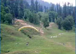
Morning proceed to visit the Solang Valley, which offers fine views of glaciers and snow, capped peaks. A place not to be missed is Rohtang Pass, 51 km from Manali at an altitude of 3978 meters (subject to weather conditions). Rest of the day is at leisure or take a stroll down the Mall road, Night stay in Manali.
Activities : Hill Stations & Valleys
Morning after breakfast at hotel drive to Manikaran in Parvati valley. Manikaran has the World’s hottest Suplhur Spring Waters and is a holy place for Hindus & Sikhs alike. Drop at Bhuntar/ Manali Bus stand to pickup Volvo AC Bus for onward destination. End of our services and Tour.
Activities : Hill Stations & Valleys
IMPORTANT INFORMATION FOR INDIAN AND FOREIGN TOURISTS
The Kinnaur and Spiti area of Himachal Pradesh has been opened to Indian and Foreign tourists. While going via Shimla and Rampur - Kalpa, Recong Peo and Sangla Valley can be visited by Indians and Foreigners without any restrictions. To travel beyond Jangi in Kinnaur to Kaza in Spiti one requires an inner line permit for foreign nationalswhichcanbeobtainedfromthefollowing offices:
DistrictMagistrate- Shimla,RecongPeo(Kinnaur),Kullu,Keylong(Lahaul)
SubDistrictMagistrate(SDM)- Shimla,Rampur,Kalpa,Nichar,Keylong,Udaipur
AdditionalDeputyCommissionerOfficeinPoohandKaza.
The best place to get the permit is at Rampur and Recong Peo. The office of the SDM at Rampur is just opposite the Police Station in the main bazaar and the office of the District Magistrate at Recong Peo is near the bus station. The permit is free of cost and holds good for seven days. To get a permit, one must have a letter of introduction from a recognised travel agency, three passport size photos, and a photocopy of the front pages of the passport. Making several copies of the permit is suggested, as one may have to submit them at checkpoints on the way. Foreign nationals can travel with permits in a group of four or more persons. Foreign nationals cannotstayovernightbetweenJangandKaza.
Indian nationals do not require any permit to travel in this area however retaining a proof of identity is suggested.
One of the celebrated tour operators in the country, Royal Himalayan Holidays India is successfully conducting its business operations from Himachal Pradesh, India. Our domain expertise, combined with a quality workforce, has enabled us to render Air Know more..


")
")
Manali - Darcha - Padam - Wanla – Lamayuru - Leh Tour (Trekking in Zanskar)
Manali - Leh Ladakh
22 Days / 21 Nights
")
 (Trekking in Himachal)")
 (Trekking in Himachal)")
")
 (Trekking in Himachal)")
Manali - Manikaran- Khirganga- Mantalai Lake (10days & 9 nights) (Trekking in Himachal)
Manali
10 Days / 9 Nights
")


Srinagar ,Pahalgam , Gulmarg, Sonamarg, Srinagar Tour
Srinagar - Pahalgam - Gulmarg - Sonamarg
3 Days / 2 Nights


Himachal Pradesh Tour Package 10 Night - 11 Days
Dalhousie - Khajjiar - Kufri - Manali - Shimla - Dharamshala - Amritsar - Mcleodganj
11 Days / 10 Nights

10Night Himachal Pradesh Tour Ex - Shimla
Dalhousie - Khajjiar - Kufri - Manali - Shimla - Dharamshala - Amritsar - Mcleodganj
11 Days / 10 Nights


9 Night - 10 Days Himachal Pradesh Tour Package - 2
Dalhousie - Khajjiar - Kufri - Kullu - Manali - Shimla - Dharamshala - Amritsar - M..
10 Days / 9 Nights


6N Shimla - Manali Tour Package Ex - Delhi
Chandigarh City - Kufri - Manali - Shimla
7 Days / 6 Nights


06 Nights 07 Days Spiti Package From CHANDIGARH VIA Cab To CHANDIGARH VIA Cab
Manali - Lahaul & Spiti - Kaza - Tabo - Chandigarh City
7 Days / 6 Nights