+91-8929175340
7 Nights / 8 Days
You will have to reach Srinagar on this day and meet the Qasrul umara hike team at 6 pm. The process of your registration, health screening, and document verification will take place at Srinagar at a common place, close to Dal Lake along with your rental gear collection. The next day, the team will leave at 5.30 am in the morning and drive to Shitkadi. The drive will take around 3-4 hours.
Drive Distance: 60 km | Drive duration: 2 hours
Trek distance: 11.6 km | Duration: 6.5 hours
Altitude gain: 7,800 ft to 11,607 ft
Trek gradient: Moderate. 3 hours of steep ascent followed by descent for an hour. Final 2 hours, a gentle ascent to Nichnai.
Water sources: Carry sufficient water from Sonmarg. You will find sources along the trail to refill your water bottles.
You will have to reach Srinagar on your own the previous day and meet the Qasrul umara hike team at 6 pm. The process of your registration, health screening, and document verification will take place at Srinagar at a common place, close to Dal Lake along with your rental gear collection.
The next day, the team will leave at 5.30 am in the morning and drive to Shitkadi. The drive will take around 3-4 hours.
The trek starts 3 km out of Sonamarg, on the Srinagar road from a place called as Shitkadi. Exactly at the 3 km mark, you will spot a lone Dhaba on the right. The place sells packaged water, biscuits and other edibles and is your last place to pick up short eats. The next trace of civilization is only at Naranag, where the trek ends. Today's trek consists of a 3 hour ascent followed by a 1 hour descent and finally a gentle 2 hour ascent to Nichnai. A jeep track diverts to the right off the main road at the shop. The track goes down to the level of the Sindh river which flows in between the mud track and the main road. The trekking trail starts along the track but quickly diverts higher up. 10 minutes into the trek, the trail bends left and enters a green meadow. This directly overlooks Sonamarg town.
In half an hour you are at the top of the meadow where Maple and Pine trees start. At the tree line, the trail quickly descends to a tiny brook and then climbs again. What follows next is a lovely dense forest of Maple trees. Walking on the green bed of grass amidst the Maples is an experience unique to Kashmir in India. For the next hour and a half, the trail winds up through the Maple trees. Stick to the trail heading uphill as the one going down heads to some of the nearby villages. The trees give way to clearings in between. Turn around and see the view of the Sonarmarg valley which gets better and fuller as you gain height. The Maple forest ends at the top of the ridge and, on the other side, a meadow gently slopes down. Spend a few moments at the ridge grasping the Sonarmarg view and its neighbouring valley. The streams, the meadows, the pines and the town nestled in them make a wonderful picture.
The climb is now over and the trail slopes down into a meadow. The meadow is lined on the left by Silver Birch trees and a few shepherds' huts. The carpet of green rolls down from the trees to the end of the 40 feet wide meadow. Small brooks which cross the meadow serve as water sources. On the right are small peaks with snow powdered tops. This is Shekdur.
Shekdur is a beautiful meadow surrounded by Bhoj trees. Have lunch here before moving ahead to Nichnai. The meadow of Shekdur stretches for half an hour. The gentle descent on the meadow ends in a forest of Bhoj or Silver Birch. Take the trail that goes in the middle of the forest and continues to descend gently. Watch out for the sun rays making their way in between the thick foliage giving out beautiful light and dark rays. In 45 minutes, you reach the end of the Birch trees and the trail goes down and climbs back into a river valley. The river valley is the beginning of Nichnai.
The trail now is along the right bank of the river going upstream. Look behind to see snow- clad peaks from Sonarmarg valley. You are now in a wide valley but enclosed by mountains on either side. The river, which joins the Sindh eventually, flows in speed through the valley. The first 30 minutes is over the rocks and your mules will walk very slowly over here. An hour into the river valley, green patches devoid of rocks open up. The river valley widens and you can see the green meadow widening in between the two mountain ranges. Far ahead lie triangular twin snow-clad peaks. Choose a flat ground to pitch tents and end the first day's trek.
Trek distance: 13.5 km | Trek Duration: 7 hours
Altitude gain: 11,607 ft to 12,011 ft via 13,229 ft
Trek gradient: Moderate. 1.5 hours of gradual ascent followed by an hour-long climb to the pass. A steep descent from the pass for about an hour easing off into a flat walk.
Water sources: Carry sufficient water from Nichnai. You will find sources along the trail to refill your water bottles.
The day's trek is a long walk on meadows with the scenery changing for the better all along. Start by 8:00 am to give yourself enough time en route to enjoy the meadows. Your first milestone for the day is the Nichnai pass or Vishnusar Berry. The pass is visible at a distance from the camp site. It lies just to the right of the twin snow-clad peaks. After half an hour of walking along the river, cross the river to move to its left bank. For the next hour, walk on the left bank. Notice that the trail slowly starts ascending as you traverse through the meadow. The following one hour is a climb to the pass. It is a medium climb to Nichnai pass, 13,500 ft, followed by a small descent followed by a long flat meadow walk ending near Vishnusar Lake. As you climb, notice a small lake at the foot of the mountains. It is a deep blue lake and you can sense your expectations rising with regards to the lake.
The pass is deceptive such that the ridge seen from the meadow below is not the pass. The trail turns inwards twice and only then does the Nichnai pass come up. From the Nichnai pass, observe the Sonamarg valley and the trail you came on. BSNL phone networks tend to work here most of the time. This is the last point on the trek where you get a phone network. The next sign of network is only when you move beyond Gangabal.
The Nichnai pass feels like a wide tunnel. On the left stand a series of snow-clad peaks. There are no peaks on the right but the land raises on the right too. Nichnai pass is at an altitude of 13,229 ft. You are just into your second day of the trek and this, by any standard, is a very fast ascent. It is not uncommon for people to feel the altitude on the climb to Nichnai pass. The good news is that the trail descends from here. The rocky trail descends rapidly. In the next hour, the rocks give way to grass. Red flowers spring out next to your feet. What you see ahead is a wide green meadow stretching for miles with mountains lining the sides. A new river flows down from the pass into the meadow ahead.
Stop here and take a view of the peaks, the river below and the flowery meadow. Notice to your left a big waterfall splashing down the mountain cliff and joining the river. From the waterfall, the rapid descent ends and you are now walking through the flat wide meadow. On the left are the classic snow-clad Himalayan mountains but notice on your right, grey and barren mountains resembling the Ladakh ranges.
Walk along, in between the two ranges, over the lush green carpet of grass. Two main streams flow through the valley. Stick close to the stream on the left. In half an hour, brace yourselves for another stream crossing. The water is icy cold.
Continue in the meadow for an hour and a half until you reach the end of the valley. Another stream flows perpendicularly from your left to your right. This stream originates at the Vishnusarlake which is a bit higher on your left. The lake is not seen yet and cannot be seen from the camp site. Pitch your tents anywhere besides the stream coming from the lake. There is ample camping space.
If you get some time you can explore the twin lakes now.
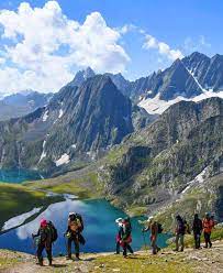
The Vishnusarlake lies 0.5 km to the left and 100 feet above the camp site. Head left and follow the stream without crossing it. The lake is two mounds away and takes about 7 minutes to reach. The first impression you get on seeing the Vishnusarlake is that it is big. It lies nestled below 4 mountains. The Kishansar peak though 0.5 km away, reflects in the lake. The reflections are wonderful when the lake is still. The colour of the lake depends on the time of the day and the clouds in the sky. Early in the morning, before the sun really shines, expect clear colourless water. The lake starts getting its colours when the sun shines. On a clear sunny morning, the water is absolutely blue. Clouds and the evening sun make it look greenish blue in the later half of the day. Whatever be the colour, the lake looks wonderful and it is worth catching a glimpse of the lake in all its hues.
Trek distance: 16 km | Trek Duration: 7.5 hours
Altitude gain and loss: 12,011 ft to 10,706 ft via 13,715 ft
Trek gradient: Moderate difficult. 1.5-2 hours of steep ascent followed by 1 hour of steep descent, easing off into a level walk.
Water sources: Carry sufficient water from Vishnusar. You will find sources along the trail to refill your water bottles.
The next part of the trek is from Kishansar lake side to the top of the ridge. You see a pencil thin line traversing through the mountain side. That is your track to follow. Always stick to the one going higher though any of them will take you to the top. It is an hour and a half climb to the top of the ridge at a moderate pace. 45 minutes into the climb, you will be treated by one of the loveliest views you can ever imagine. Both the Kishansar and Vishnusar lakes, in full view, together.
The view of the twin lakes lasts till you reach the ridge top or the Pass. This is called the Gadsar pass – altitude 13,800 ft – the highest point on this trek. The trek is a steep 2-hour ascent followed by a steep descent followed by a gentle walk in the meadows. On the other side of the Gadsar pass stretches a long valley with 2-3 small lakes visible. Far in the distance lie a series of snow-clad peaks. The peaks lie outside our Line of Control. It is not uncommon to find snow at the Gadsar pass and also in the initial parts of the descent to the other side.
The descent is straightforward. The first small lake that is seen on the left is the Yamsarlake. The locals believe that Lord Yama has some association with the lake! Beyond Yamsar is another nameless lake. An hours descent leads you into flat meadows again. This valley is narrower with two ranges running on either side. Notice the multi-coloured flowers growing up, out of the green grass. It starts with red and moves on to blue and purple Iris flowers.
When you are in the blue Iris area, you are almost at Gadsar – one of the prettiest and most pristine of the lakes on this trek. Gadsar is at the base of snow-clad cliffs. Blue flowers spring up on one side and snow slabs fall into the lake from the mountain on the other side. Look ahead to see the green-blue valley gently slope down. The Yamsar, the nameless lake and Gadsar are all connected by a stream of water that flows from the higher lake to the lower. Gadsar is again at 12,500 feet.
Choose to make Gadsar your camp site for its sheer beauty but only if you can vow to leave the ground as neat as you found it to be. Usually no one camps at Gadsar. There is a small abandoned army shelter near Gadsar.
If you choose not to camp next to Gadsar, the next place to camp would be the Gadsar army camp. Continue on the downward trail from Gadsar and in half an hour the valley widens up. Spot another blue lake on the left of the valley. Notice the snow clad mountains now give way to lower barren mountains. You have lost considerable altitude again. In another half an hour down the trail, a few shepherds' huts come up. Continue downhill and at the end of the third half hour, the army camp comes up. Gadsar army camp is just a small hut housing 5-8 army men.
To move beyond the army camp, one needs permission from their Headquarters. The Headquarters is 4.8 km further away down into the tree line near a village. The Gadsar camp communicates with the HQ through walkie-talkies. The HQ is equipped with a satellite phone for the army. If you are near the Gadsar army camp, it is best to report to them as soon as possible. It takes 2-3 hours for their green signal to come through. All details of the trekkers and staff, including original identity cards, are recorded, collected and checked.
Trek distance: 11.5 km | Trek Duration: 4.5 hours
Altitude gain: 10,706 ft to 11,985 ft
Trek gradient: Moderate; 1.5 hours of steep ascent followed by a level walk.
Water sources: Carry at least 2 litres of water from Gadsar. You will find rivulets along the trail but the water might not be suitable to drink.
After crossing the stream, take the trail that goes up the mountain. The trail now looks like a typical western ghats trail. The terrain feels very similar. You are just above the tree line. Trees and the river valley are visible below you. The hour and a half long climb takes you up by 1,100 feet. Once beyond the 11,500 feet altitude, the climb graduates to a traverse. The trail bends round to the left and leaves the river valley. You are now walking on a flat trail surrounded by mountains on a meadow. To your right are a few deep craters. This place is called as Maengandob. The landscape ahead is captivating. Isolated mountains stand in front. Towards the right is a small ridge. In between is a flat green bed with a stream flowing through. Choose to camp here if Gadsarlake was your last camp. If the army camp is where you started, it makes sense to cover a little more distance today and camp near the first of the Satsar lakes. Satsar is actually a collection of 7 lakes. You can find 4 or 5 lakes with water, depending on the season. Beyond the ridge, on the right, is the Satsar army check post. It is the 3rd line of defence from the LOC. The same process of identity checking, collection and questioning repeats here. Finish this today so that tomorrow is a clean day of trekking. Ten minutes out of the army camp is the first of the Satsar lakes. The lake is pretty big and looks picturesque in its green setting with mountains in front. Choose a place to camp here for the day.
Trek distance: 9 km | Trek Duration: 6 hours
Altitude loss: 11,985 ft to 11,486 ft via 13,276 ft
Trek gradient: Difficult. 30 minutes each of gradual ascent and descent followed by a steep ascent for about 45 and then by a steep descent. Similarly ascending and descending trail all the way through.
Water sources: Carry 2 litres of water. You will find a stream mid way during the descent to refill your water bottles.
Mild ascent followed by gradual descent followed by a long steep ascent and long steep descent followed by gradual up and down walk. The day's trek goes up and down replicating the trek as a whole which mostly goes up and down. Trek up half an hour out of camp, to reach the biggest Satsarlake. The terrain is bouldery and it is more of a boulder hopping exercise than anything else. The biggest of the Satsar lakes is also the last in the sequence. After the last lake, the trail starts to descend. Continue for half an hour on the main trail until you see the forest line ahead to your left. The right side is a ridge line, about 1,000 ft higher. It is time to gain height again. The altitude at the base of the climb is 11,800 feet. Take the zig-zag pony track to climb up to the top of the first ridge. A 45-minute trek with limited breaks will see you on top of the first ridge. Once on top, you see two more ridges to climb. The trail from the base to top is barren and rocky. Looking behind at the opposite mountains, spot the Gujjar huts amidst the tall pines. You will not fail to notice the bareness of the mountains here and the greenery on the other side.
A total of two-hour ascent brings you to the top of the 3rd ridge. The altimeter reads about 13,400 feet. The best part, however, is the surprise view you get from the ridge top. The two lakes lie next to one another. A stream takes water from the higher lake to the lower. If you look keenly, two more blue lakes are seen, one on either side at a distance. The smaller lakes are nameless but the biggest amongst the set is the Gangabal. Its companion is the Nandkol. You now know your destination. It is 1,400 feet below you. The route descends a bit more and ascends again to the lake. Take pictures of both sides and brace yourself for a steep stony descent. Your destination is either the Gangabal or the Nandkol. The ascent is dry but on the descent, you cross a stream mid way. Fill your empty bottles with cold water and move on. An hour and a half steep descent brings you to green meadows again. The meadow is not too wide but stretches from your right to left. A kilometre down left, you see the tree line again. Once at the base, the lake shore is still a good distance. The destination is seen but seems far away. A quick climb, a shorter descent and a stream crossing over a wooden log bridge brings you to the shores of Nandkollake. Notice that this lake is not as pristine as the other lakes you saw on the trek. Remnants of camping are all around. A lot of people trek up from Naranag to Gangabal and go back as a weekend outing. You will wish they spared time and thought to clean up the mess they created by these beautiful lakes.
The Nandkollake lies at the base of the Harmukh peak. The Harmukh glacier hangs on the sides of the rocky edges of the mountain. Both the Gangabal and Nandkol are famous for trout fishing. The Gangaballake is about 20 minutes away from Nandkol. A fiery stream flows on the right of the two lakes connecting them. The stream has to be crossed to go to Gangabal from Nandkol. Do not try to cross the stream at the lower levels but go all the way to the bank of Gangabal and on the right you find a good man-made bridge laid out. Gangabal is huge. A parikrama of either of the lakes will easily take an hour.
Trek distance: 13 km | Trek Duration: 6 hours
Drive Distance: 2 hours | Drive Duration: 50 km
Altitude loss: 11,486 ft to 7,800 ft
Trek gradient: Moderate. A mix of ascents and descents for 6 km followed by a very steep descent all the way down.
Water sources: Carry sufficient water from Gangabal. You will find sources along the trail to refill your water bottles.
The day's trek is a killer on your toes and knees, it is a gradual descent followed by a steep descent. From the Gangabal camp site head down along the stream towards the tree line. Don’t walk beside the stream but walk along the ridge on the right. 30 minutes into the trail, your Aircel phone could catch network, just enough to inform home that you are alive! The ridge ends and you descend to a green and a flat meadow on the right.
The Harmukh peak looks impressive when you look back. The green meadow has little yellow flowers growing all over and you start walking gingerly to avoid stepping over them.
An hour out of the camp site, you hit the fringes of the tree line. Pine trees line the meadows and you also see traces of civilization with the presence of a log hut. Do not walk into the forest directly but stick to its fringes and walk towards the right. As a trademark of this trek, you don’t lose altitude now but start to climb up a bit. You drop to 10,800 feet at the tree line but climb again to 11,000 feet. For about 6 km you never really lose altitude and you are forever around the 10,800 feet mark, making your way in and out of the Pine forest and finally entering it fully.
Only after walking for 2/3 of the distance does the true descent begin. The descent is now really steep. The trail is a well-trodden, muddy one through the thick of the pines. The last 4 km see you dropping more than 3,000 ft. It is not rare to spot a lot of people trekking up here from Naranag, headed to Gangabal. Naranag slowly comes in sight at around 8,500 ft but there is quite a bit more to go. The last stretch of the last day does become an endurance test but soon the stone-paved village track comes up and in no time you enter the main road of Naranag. Drive to Srinagar and reach by 6.30 pm. Stay overnight at Srinagar.
Note: Some stay options if you have an extra day at Srinagar – Hotel german ResidencyHotel Shefaf, Hotel Royal Samad, Deluxe Group of Houseboats
For all your travel plans include a buffer day to accommodate bad weather on the trek/political instability.
This depends completely on the circumstances of the trek and the situation in Kashmir.
If the buffer day is used, you have to pay us Rs. 1,800 per day (INR) +5% GST. The money will be collected by the Trek Leader only if we use the buffer day.
Qasrul-Umara, a reliable tour operator in Srinagar (Jammu & Kashmir), specialized in creating personalized itineraries for travelers and holidaymakers visiting Jammu & Kashmir and Ladakh based on their personal needs and desires. Our aim is to offer cost-effective Jammu & Kashmir and Ladakh tours to all travel enthusiasts located across the world.
We can help people to find suitable, cozy stays in top-rated hotels, luxury resorts, guest houses, motels, and other lodgings where they can feel safe and comfortable and enjoy luscious food. We have maintained a fleet of cars and other vehicles and can provide rental vehicles which are handled by highly disciplined and trained drivers. Besides, we provide assistance for the private and corporate event management needs of our customers.
Qasrul-Umara was established with the aim to set high traveling standards and achieve the highest level of customer satisfaction. All of our tour packages are designed as per visitors’ choice, needs, and budget limits. We offer extraordinary services at a discounted rate to our customers and take utmost care of their privacy and safety.
We are blessed to have a sincere and experienced team that is always ready to assist our customers and make them experience real fun & adventure on their Jammu & Kashmir and Ladakh tours.
If you want to get the ultimate experience in Jammu & Kashmir and Ladakh, then you can count on Qasrul-Umara. With a good understanding of your desires, we are competent in providing you with a real sense of gratification and turning your dream vacation in Jammu & Kashmir and Ladakh into a reality.
Read More...
 5D/4N
5D/4N
 7D/6N
7D/6N
7 Days Vaishno Devi - Kashmir Tour Package
Katra - Srinagar - Pahalgam - Sonamarg - Gulmarg
 9D/8N
9D/8N
Kashmir 8 Nights - 9 Days Tour Package
Srinagar - Pahalgam - Sonamarg - Gulmarg
 6D/5N
6D/5N
Kashmir 5 Nights 6 Days Tour Package
Srinagar - Kashmir - Pahalgam - Sonamarg - Gulmarg
 8D/7N
8D/7N
7 Night - 8 Days Kashmir Tour Package
Srinagar - Sonamarg - Gulmarg - Pahalgam - Kashmir
 7D/6N
7D/6N
6 Nights 7 Days Vaishno Devi - Kashmir T..
Katra - Srinagar - Pahalgam - Sonamarg - Gulmarg
 6D/5N
6D/5N
Kashmir 5 Nights - 6 Days Tour Package
Srinagar - Pahalgam - Sonamarg - Gulmarg
 6D/5N
6D/5N
5 Nights - 6 Days Kashmir Tour Package
Srinagar - Pahalgam - Sonamarg - Gulmarg
 8D/7N
8D/7N
 8D/7N
8D/7N
") 8D/7N
8D/7N
 8D/7N
8D/7N
 8D/7N
8D/7N
 8D/7N
8D/7N
 8D/7N
8D/7N
 8D/7N
8D/7N
 8D/7N
8D/7N
 8D/7N
8D/7N
Delhi Shimla Manali Honymoon Package
New Delhi - Shimla - Manali - Chandigarh City
 10D/9N
Jammu And Kashmir Tour Package 9 Night -..
Katra - Patnitop - Srinagar - Kashmir - Pahalgam - Sonamarg - Gulmarg
 5D/4N
5D/4N
 6D/5N
6D/5N
5 Nights - 6 Days Kashmir Tour
Srinagar - Kashmir - Pahalgam - Sonamarg - Gulmarg
 7D/6N
7D/6N
6Nights Kashmir Exploration Tour
Srinagar - Kashmir - Pahalgam - Sonamarg - Gulmarg
 6D/5N
6D/5N
 6D/5N
6D/5N
 5D/4N
5D/4N
 5D/4N
5D/4N
 8D/7N
8D/7N
Glorious Kashmir with Vaishnodevi
Kashmir - Srinagar - Pahalgam - Gulmarg - Sonamarg - Katra - Vaishno Devi Temple