13 Nights / 14 Days
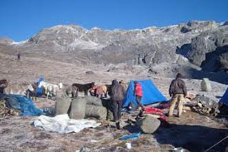
This is one of the most difficult treks in Bhutan due to the high altitudes and steep ascents and descents along the path. Moreover, this trek is measured as one of the most scenic treks in Bhutan. This fourteen day, 217 km journey begins from Drugyel in Paro and traversed through Lingshi, Laya and Lunana, the districts that have different piece of Bhutanese society with unique culture, traditions and appearance. The trek provides majestic views of Bhutan Himalayas.
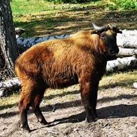
Apart from mountains, you will be able to spot animals such as Blue Sheep and Takins. The trek also offers a day of recreation at the famous Gasa hot springs.
Best seasons: April-June and Mid-September-Mid-November.
Distance: 15 km
Time: 5hr
Ascent: 310m
Descent: 80m
Walk along the dirt road through wide, rich, cultivated valley, beneath forest-covered mountains, following the Paro Chhu. You will encounter the first settlement comprising of big, magnificent traditional buildings with bright red chillies dried on their roofs in season. Not far from here, at Gunitsawa, you will pass army check point and your trekking permits will be checked and endorsed here. The Shana campsite is just half an hour walk from here.
Distance: 22km
Time: 6-8hr
Ascent: 685m
Descent: 0m
This is a hard day as the altitude gain is above the limit. You will come across the first bridge en route from Tibet to Bhutan that was used by the travellers once upon a time. The trail climbs steadily through beautiful thick forest consisting mainly of, Oak, Rhododendron, Bamboo, Fern, Birch, Fir, Larch, Maple and Blue Pine. The route has lots of small rises and drops with a vision of amazing snow-capped Jhomolhari on the north. The hard day of walking comes to an end at Soi Thangthanka camp, which is in a big meadow.
Distance: 17km
Time: 4-6hr
Ascent: 469m
Descent: 0m
The view of Jhomolhari fades away as you leave the camp inflowing forest on the way towards the Army camp. Late in spring, Blue Poppy (Bhutan’s national flower) has been spotted. The Military camp has Bhutanese and Indian army personnel guarding another pass to Tibet. The trail takes you through six remote villages and you might be invited into one of the houses for a cup of famous butter tea. After crossing the settlements, the summits of spiky peak Jitchu Drakey, Tshering Kang and Jhomolhari appear to get closer. Cross a bridge and suddenly the irresistible snow-and-ice- covered east face of Jhomolhari appears, with its massive 3200m- high wall of granite, marble, and quartzite. You have reached Jhomolhari camp.
Rest day at Jhomolhari camp will help with acclimatisation as most people will feel the effects of ascending 1800m in three days. There are some good day hikes from the camp, and it is important to hike so that you will acclimatise. Follow the standard trek rule: trek high, sleep low.
Distance: 21km
Time: 5-6hr
Ascent: 845m
Descent: 880m
It is a long climb to reach the first high and very windy pass of this trek, Nyile La pass. From the pass, you can get the views of overpowering mountains covered with snow. The route descends from the pass leading to a viewing point from which Lingshi Dzong can be seen in its full glory; a powerful, solitary structure in the middle of an enormous wilderness. Further 900m descend, you reach Lingshi camp. You can walk around Lingshi village and visit the Dzong.
Distance: 16km
Time: 3-4hr
No major elevation gain or loss
The route from Lingshi to Chebisa is the most pleasant walk of the trek. The hillsides are partly roofed with medicinal plants. The route passes through a small pass and a village with few households. There is a Dzong in the village which was renovated in 2003 by the community. After visiting the Dzong, continue walking and Chebisa campsite is reached after crossing a little pass.
At the end of the valley, a trail leads into Tibet. The extraordinary medicinal plant “Delphinium brunonianum” ‘Royal’ can be found. It is a beautiful, light purple, delicate-looking flower, which booms in the summer and has a musky aroma. The seeds are collected in summer.
Distance: 14.5km
Time: 5hr
Ascent: 450m
Descent: 440m
The track leading to a peak called Inela through the grassy slope of the village is rigid and vertical. On the way you might see herd of Himalayan Blue sheep, and possibly bearded vulture. The trail levels out and traverses a pass- Gombu La. From the pass, the greasy (sometimes) route descends towards the valley covered with Rhododendron forest. The trail passes some rock cliffs containing salt minerals and towards the end of the hike, the route descends through the forest on a wet trail to the valley of Shakyapasang campsite. The valley is one of the more stunning ones on the trek.
Distance: 16km
Time: 7-8hr
Ascent: 160m
Descent: 785m
The day begins with a short climb and later levels and changes the direction. Watch for herd of Himalayan Blue sheep; snow leopard footprints have been spotted here. Jare la is a small pass with several cairns and prayer flags, which marks the border between Lingshi and Laya for grazing Yaks. Jare la is a good viewing spot. You can see magnificent snow-capped Himalaya. Now the descent starts steeply snaking through Rhododendron bushes, Spruce, Larch, Silver Fir, Oak and various Pines and grassy slope all the way down to the valley. After crossing numerous rivers and swampy valleys you reach Robluthang campsite.
Distance: 14km
Ascent: 840m
Descent: 840m
The trail crosses several streams and a pass Sinche la. The trail is more of zigzag, grassy and slippery till the end. The trail gets you through glacial valley and yak pasture lands, and the lowest point in the horizon as well. The hillsides are roofed with medicinal plants “Rheum nobile” and there is possibility of seeing Blue sheep. The route offers great views of five Bhutan Himalayas ranging from 4617m to 7194m above sea level. From here, continue descending through some huts until you reach sandy place next to a moraine. 20 minutes after crossing a bridge, Limithang campsite is reached walking through beautiful Cedar forest.
Distance: 9km
Time: 4hr
Ascent: few small climbs
Descent: 360m
The route crosses several streams, Cedar and Fir forest with an immense view of the Great Tiger Mountain. After some small ups and downs and crossing a ridge you reach a Chorten and prosperous Laya village with Tsenda Gang Peak in the distance to the northeast. Laya geog has six villages and it is part of the Jigme Dorji National Park.
Walk around Laya village, it’s a worthwhile. You can visit some of the houses and the hosts will be happy to have a guest, but watch out for dogs! There is a school in the village and few Temples were you can visit. If you feel little adventurous, go for Yak riding! Apparently there are more than 20 yaks that are safe enough. There are some good hikes from Laya.
Distance: 16km
Time: 6hr
Ascent: 0m
Descent: 560m
Walk through the pasture and houses towards the village access and pass through some beautiful woodland. The trekking permits are checked at the army check point called “Take Hankhar.” After the army camp, the trail is good and it descends till the bottom of the valley. From the valley, the trail is good, wide and flat following Mo Chhu. Two massive caves are met on the way while climbing. At the end of the final climb, the trail provides a good view of Koina Chhu and the Koina campsite. The campsite is muddy and there is a hut and appropriate toilets, which is clean and well looked after by a caretaker.
Distance: 12km
Time: 6hr
Ascent: 660m
Descent: 1680m
Start the day with a trail through sub-tropical forest passing Georges and if the atmosphere becomes hazy, the canyon transforms into something out of a folk tale. On the other side of the canyon is one of the few places in the world where the Snow Leopard and Tigers use the same province. After 3hr of climbing gains Bale La, the last pass on this trek, and now the trail gradually descends till Gasa. Kang Bum Mountain can be seen through cane forest. There are few shops in the centre of the one-street village. One hour steep descends from Gasa leads to the Gasa campsite near the Hot Springs.
Day 14
Gasa to Punakha
After a night at the hot springs, take the snaking trail to Damji through beautiful Pine forest. You will get picked up by car from Damji and transfer to the hotel in Punakha.
To foster meaningful connections with our country, Bhutan Instant Travel, with its dedicated staff, offers its clients various tours with specials such as safaris, hot springs and home stays amongst others.
If you are looking for an entirely unique travel beyond the regular tours that we provide, fret not, because we also offer customized itineraries to suit your interests.
From providing accurate information and prompt response to taking care of your desired comfort, we, with our experienced guides and drivers, commit to arrange memorable holidays for you so that you leave with every sense of satisfaction. Read More...

 4D/3N
4D/3N
 7D/6N
7D/6N
 9D/8N
9D/8N
 8D/7N
8D/7N
 6D/5N
6D/5N
 3D/2N
3D/2N
 10D/9N
 7D/6N
7D/6N
 14D/13N
 14D/13N
 14D/13N
Rajasthan - Land of Kings & Queens Tour
New Delhi - Agra - Jaipur - Ranthambore - Udaipur - Jodhpur - Bundi - Chittorgarh -..
 14D/13N
 14D/13N
New Delhi - Agra - Gwalior - Bhopal - Indore - Mumbai - Chhatarpur - Tikamgarh - Au..
 14D/13N
New Delhi - Mandawa - Bikaner - Gajner - Jodhpur - Kumbhalgarh - Chittorgarh - Bund..
 14D/13N
Guwahati - Shillong - Tawang - Kaziranga - Kohima - Imphal - Silchar - Cherrapunji ..
 14D/13N
Munnar - Thekkady - Alleppey - Thiruvananthapuram - Kovalam - Kanyakumari - Kochi
 14D/13N
New Delhi - Shimla - Dharamshala - Dalhousie - Chandigarh City
 14D/13N
 5D/4N
5D/4N
 15D/14N
Himalayan Odyssey 14 Nights - 15 Days Tour
Thimphu - Paro - Wangdue Phodrang - Punakha - Mongar - Bumthang - Trashigang
 8D/7N
8D/7N
 16D/15N
15 Nights/16 days Merak Sakteng Trekking..
Thimphu - Paro - Punakha - Bumthang - Trashigang
 10D/9N
Thimphu - Paro - Wangdue Phodrang - Punakha - Trongsa - Bumthang
 7D/6N
7D/6N
 5D/4N
5D/4N
 7D/6N
7D/6N
 7D/6N
7D/6N
6 Night 7 Day Wonderful Bhutan Tour
Thimphu - Paro - Wangdue Phodrang - Punakha