"Explore diverse wildlife in pristine landscapes."
Kora National Park is a protected area in Kenya, located in Tana River County. It covers an area of 1,787 square kilometers and is situated along the Tana River. The park was established in 1989 and is known for its diverse wildlife and stunning landscapes. It is home to a variety of species, including elephants, buffaloes, zebras, giraffes, and various bird species.
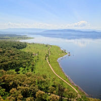
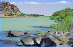
Kora National Park is located approximately 280 kilometers northeast of Nairobi. It is situated in a semi-arid region, characterized by rocky hills, acacia woodlands, and riverine forests. The Tana River, the longest river in Kenya, flows through the park and provides a vital water source for the wildlife.
The park is open to visitors from 6:00 am to 6:00 pm every day.
There is an entry fee for visitors to Kora National Park. The fee is $20 for non-resident adults, $10 for non-resident children, and 1,000 Kenyan Shillings for resident adults.
Kora National Park is home to a wide variety of flora and fauna. The park is known for its large elephant population, as well as other species such as buffaloes, zebras, giraffes, lions, leopards, and numerous bird species. The park is also home to a variety of plant species, including acacia trees, baobabs, and riverine vegetation.
Visitors to Kora National Park can enjoy a range of activities, including game drives, bird watching, nature walks, and camping. The park also offers opportunities for fishing along the Tana River.
Jeep safari charges vary depending on the duration of the safari and the number of participants. Prices typically range from $50 to $200 per person for a half-day safari, and $100 to $300 per person for a full-day safari.
Children under the age of 3 are admitted for free. Children between the ages of 3 and 12 are charged a reduced entry fee of $5. Senior citizens over the age of 60 are also granted a discount on the entry fee, with a rate of $15 for non-residents and 500 Kenyan Shillings for residents.
Kora National Park offers facilities for senior citizens, including wheelchair accessibility at the visitor center and designated viewing areas for game drives.
The best time to visit Kora National Park is during the dry season, which runs from June to September. During this time, wildlife is easier to spot as they gather around water sources, and the vegetation is less dense, allowing for better visibility.
There are several nearby attractions to visit when exploring Kora National Park. These include Meru National Park, Bisanadi National Reserve, and the Tana River Primate Reserve.
Kora National Park provides designated parking areas for visitors. It is advisable to park your vehicle in the designated areas to ensure the safety of your vehicle and to avoid any wildlife encounters.
Visitors to Kora National Park are required to adhere to certain rules and regulations to ensure the safety of both visitors and wildlife. Some of the rules include keeping a safe distance from wildlife, refraining from feeding the animals, and not littering in the park.
Kora National Park can be reached by road from Nairobi, with the journey taking approximately 6-7 hours. The park can also be accessed by air, with the nearest airstrip being the Maua airstrip, located about 50 kilometers away. It is recommended to book accommodations in advance if planning to stay overnight in or near the park.
Visitors to Kora National Park are advised to follow the guidance of park rangers and to respect the natural environment during their visit. With its diverse wildlife and beautiful landscapes, Kora National Park offers a memorable safari experience for all nature lovers.